
Selkirk–Interlake–Eastman – Existing boundaries
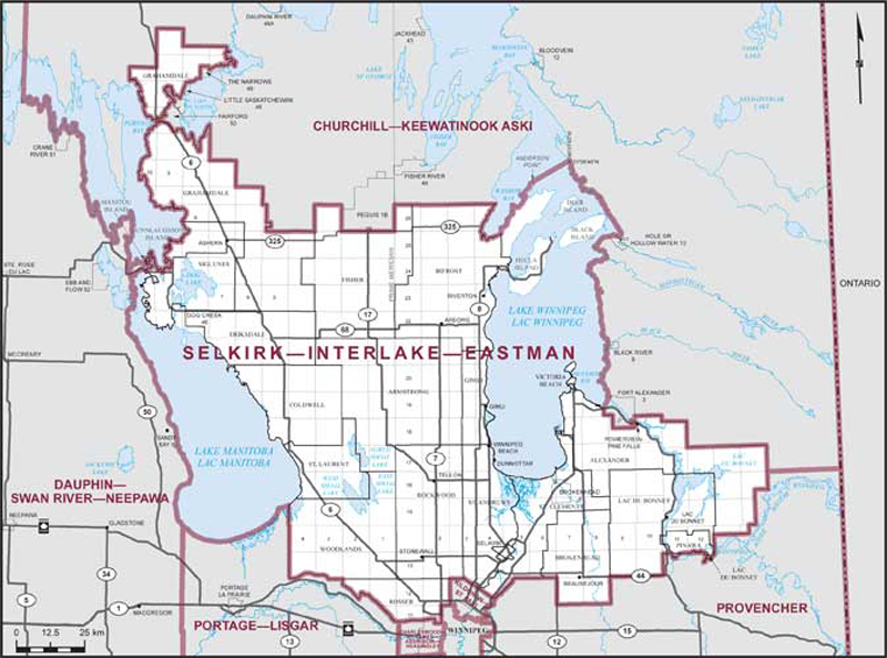
Consisting of:
- (a) the rural municipalities of: Alexander, Armstrong, Bifrost, Brokenhead, Coldwell, Eriksdale, Fisher, Gimli, Grahamdale, Lac du Bonnet, Pinawa, Rockwood, Rosser, St. Andrews, St. Clements, St. Laurent, Siglunes, Victoria Beach and Woodlands;
- (b) the City of Selkirk; the towns of Arborg, Beausejour, Lac du Bonnet, Powerview-Pine Falls, Stonewall, Teulon and Winnipeg Beach; the villages of Dunnottar and Riverton;
- (c) the Indian reserves of Brokenhead No. 4 and Dog Creek No. 46;
- (d) that part of the Province of Manitoba described as follows: commencing at the intersection of the easterly limit of the Rural Municipality of Bifrost with the southerly shoreline of Washow Bay in Lake Winnipeg at approximate latitude 51°12’24”N and longitude 96°53’54”W; thence generally northeasterly along said shoreline to the northeasternmost point of Anderson Point; thence northeasterly in a straight line across Lake Winnipeg to the mouth of an unnamed stream on the easterly shoreline of said lake at approximate latitude 51°26’40”N and longitude 96°31’45”W; thence generally southerly along the easterly shoreline of Lake Winnipeg to the northerly boundary of Fort Alexander Indian Reserve No. 3; thence southwesterly in a straight line across Traverse Bay to the intersection of the shoreline with the westerly boundary of said Indian reserve; thence generally northwesterly, generally southerly, generally westerly and generally northerly along the shorelines of Lake Winnipeg to the southerly limit of the Rural Municipality of Bifrost; thence generally northerly along said limit to the point of commencement; and
- (e) the islands of Manitou and Gunnlaugsson in the Lake Manitoba Narrows, belonging to the Rural Municipality of Siglunes.