
Comment 40 (30 August 2022) – comments and feedback
Back to all comments and feedback from the public
Matthew Hinatsu
Introduction
To whom it may concern,
My name is Matthew Hinatsu. I am a 17-year-old student who attends Shaftesbury High School and will be heading into my Grade 12 year this upcoming September. I currently live in the federal riding of Charleswood- St. James – Assiniboia - Headingley and I write to the commission because I would like to deliver feedback back about the new proposed riding of Winnipeg West. As I feel it unfairly represents the people in the new riding. In this submission, I have included amendments to the initial proposal from the committee which I feel would better represent myself and my neighborhood. I acknowledge that modifying the current Winnipeg West riding will change the boundaries of the surrounding ridings as well, therefore I have also proposed amendments for the surrounding ridings as well. I have also created a Riding builder map for all the ridings in Manitoba. However, these other ridings feature changes to even out population or feature no changes at all from the commission's initial proposal. It's important to acknowledge to the committee that I am not affiliated with any political party, nor did I try to draw maps in favor of any political party. I drew these maps with the sole purpose of better representing myself and my neighbors.
With that being said, when I was in the process of creating new ridings, I wanted to follow 3 key principles which were, when possible, not to break up any Rural Municipalities in drawing new ridings, secondly, I attempted to keep the partisan lean of a riding consistent with the current ridings and lastly, when possible, I grouped communities of interest in the same riding. For the information regarding population per riding and the 2021 election results in my new ridings I have created an excel spreadsheet which I have also included in my submission. I have also included my riding builder file so the commission can view my proposed ridings in more detail. Lastly, I give credit to the Manitoba Commission for the current population of the old ridings, credit to Elections Canada for prior election results and credit to Riding Builder for giving me the population and partisan leans of the new ridings.
Overall, I would like to thank the commission for their time and this opportunity for the public to input feedback in this democratic process.
Thanks,
Matthew Hinatsu
Winnipeg West
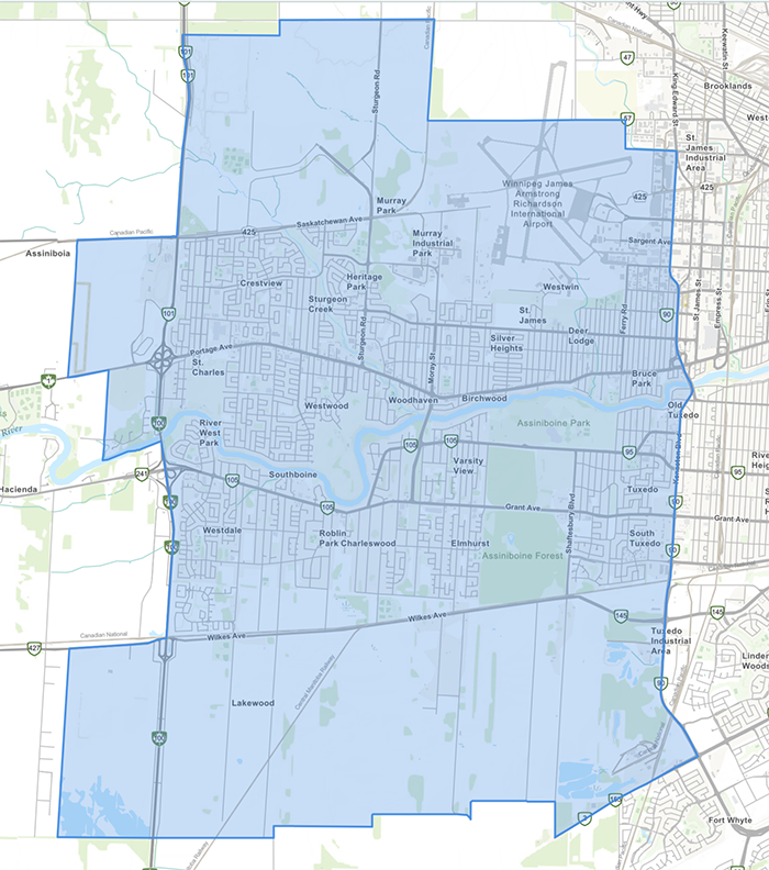
Winnipeg West Riding Description
Consisting of: the part of the City of Winnipeg lying westerly of a line described as follows: commencing where Brookside Boulevard meets Airport Road; thence moving south on said road and on to the easterly limit of James Armstrong Richardson International Airport until the boundary is adjacent with Dublin Avenue; thence move easterly until the intersection of Dublin and King Edward Street; thence move generally south as King Edward Street becomes Century Street and as Century crosses the Assiniboine River and becomes Kenaston Boulevard; thence continue south until the intersection of Kenaston Boulevard and McGillivray Boulevard; thence move westerly along McGillivray Boulevard until it intersects McCreary Road; thence move north on McCreary Road until it intersects Wyper road thence; move Westerly to the outskirts of the City of Winnipeg where the boundry moves generally north including all the outskirts of the City of Winnipeg; thence move generally east where the perimeter highway meets four mile road and outskirts of the James Armstrong Richardson International Airport to the point of commencement.
Changes Made to Winnipeg West from Initial Proposal
Out of all the ridings I've made modifications to, the riding of Winnipeg West is the most drastically changed from the initial committee's proposal, which was to bring the riding out to Headingley and further west to bring in the R.M of St. Francois Xavier, the R.M of Cartier and a portion of the R.M of Portage la Prairie into the Winnipeg West riding. As a person living in the neighborhood of Charleswood, I feel that I have a closer connection with other communities within the city like Tuxedo and St. James when compared to rural communities like Elie, St. Francois Xavier and Headingley. Although the Commission's proposal met the population tolerance of +/- 5%, I feel this riding is unfair to both urban and rural voters alike. As for the urban voters their influence is diluted by even more rural voters added outside of Headingley which would result in a riding that would not properly represent the needs of the urban population. On the flip side, adding more voters from rural Manitoba would unfairly represent rural voters as they are now combined with urban voters from the city of Winnipeg. Also, leading to a riding which would not properly represent the needs of the rural voter since the riding puts urban and Rural voters in the same riding. Therefore, in my proposal, I have moved the R.M of Headingley into the Portage-Lisgar riding along with the R.M's that were previously included in the Winnipeg West riding like the: R.M of St. Francois Xavier, the R.M of Cartier and the R.M of Portage la Prairie. In its place, I've shifted the riding east on both sides of the river leading to the eastern boundary now sitting on Kenaston Boulevard crossing the Assiniboine River and continuing north through Century and King Edward Street. This would move the neighborhood of Tuxedo, the Fort Whyte Alive Park and the neighborhood of St. James into the new riding of Winnipeg West. This new version of the Winnipeg West riding satisfies the population tolerance of +/- 5% which the commission was concerned about with the old Charleswood - St. James - Assiniboia – Headingley riding. The addition of the new neighborhoods brings the population of Winnipeg West to 97000 people (which is +1.18% above the average population per riding which is 95868). But most importantly I believe this riding better reflects the needs of both Urban and Rural voters alike with this riding now only including people from the city of Winnipeg and rural voters into the Portage-Lisgar riding. This will lead to a better representation of both urban and rural voters.
Winnipeg Centre
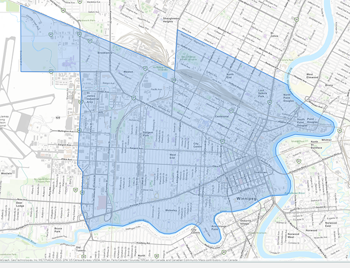
Winnipeg Centre Riding Description
The boundaries of Winnipeg Centre can be described as commencing where the Logan C.P.R railroad tracks intersect Brookside Boulevard where the line moves Southeast until it intersects Mcphillips Street where the boundary moves North until it intersects Burrows Avenue. The boundary then moves southeast along Burrows Avenue until the boundary is halfway across the Red River. The boundary then moves generally South along the Red River until it intersects the Assiniboine River where the boundary moves generally West along the Assiniboine River until it intersects the St. James bridge. The boundary then moves generally North along Century Street. When Century Street splits into 2 different roads the boundary turns slightly west and then follows King Edward Street north until King Edward Street intersects Dublin Avenue. Along Dublin Avenue, the boundary then moves west until Airport Road where it moves north to Notre Dame Avenue then continues west until it intersects Brookside Avenue. The boundary then moves North along Brookside Avenue to the point of commencement.
Changes Made to the Winnipeg Centre Riding
The riding of Winnipeg Centre is one that is situated in the heart of Winnipeg and therefore I had to make major considerations before I made any modifications to the Winnipeg West riding. As taking too much population from this riding would result in it being under the population tolerance of +/- 5%. Since moving the boundary east to Century and King Edward Street brought the population under -5% in Winnipeg Centre I had to bring in some population from the Winnipeg North riding to counteract the population loss by moving the riding boundaries further east. So, I ended up adding the population from a section starting from moving north along Mcphillips Street then, east along Burrows Avenue until Burrows met the Red River. This ended up adding enough population to meet the population tolerance of +/-5% with the riding ending up with 93365 people or -2.61% of the mean riding population of 95868 people.
Winnipeg South Centre
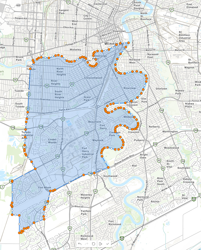
Winnipeg South Centre Riding Description
The boundaries of Winnipeg South Centre can be described as commencing where the Assiniboine River intersects the St. James Bridge and moving South along until Kenaston Boulevard intersects McGillivray Boulevard. From McGillivray, the boundary then moves Southwest to Brady Road where the line moves south until Brady Road meets Bison Drive where the boundary then moves generally east along Bison Drive until Bison Drive meets Kenaston Boulevard. Once along Kenaston Boulevard the line moves North to Bishop Grandin Boulevard and East until the boundary is halfway through the Red River. The Boundary then moves generally North along the Red River until the Assiniboine River meets the Red River then moves West along the Assiniboine River to the point of commencement.
Changes Made to the Winnipeg South Centre Riding
The riding of Winnipeg South Centre has also undergone some changes after neighborhoods like Tuxedo and the Fort Whyte Alive Park got removed to be in the new riding of Winnipeg West. The removal of Tuxedo was already planned in the initial proposal from the committee. So, the only change from the proposal regarding the riding of Winnipeg South Centre is the removal of the Fort Whyte Alive Park and some apartment buildings which brings the population of Winnipeg South Centre to 98183 people or 2.41% over the mean population of 95868 well within the +/- 5% tolerance set by the commission.
Portage-Lisgar
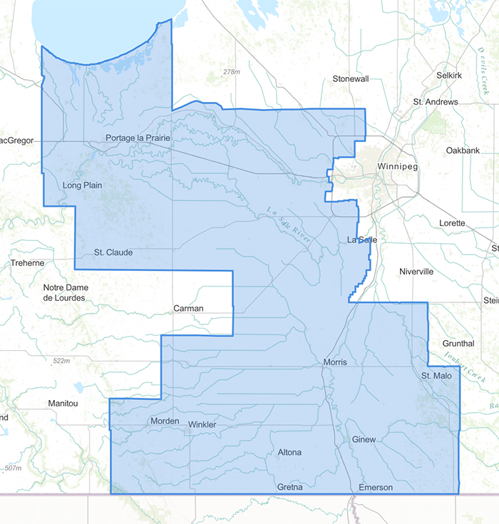
Portage – Lisgar Riding Description
The boundaries of Portage – Lisgar can be described as the region of Manitoba West of Winnipeg stretching south to the USA / Canada border and going as far north to the southern portion of Lake Manitoba. This riding includes the Rural Municipalities of: Portage La Prairie, Rosser, St. Francois Xavier, Cartier, Grey, Macdonald, Morris, De Salaberry, Franklin, Montcalm, Rhineland, Stanley and Headingley.
Changes Made to the Portage – Lisgar Riding
In the rural Riding of Portage – Lisgar several changes were made to accommodate the modifications made to the new Winnipeg West Riding. As I added back the R.M's of Cartier, Headingley, St. Francois Xavier and the portion of Portage la Prairie back to this rural riding. However, this would bring the population of the riding to well above the +5% tolerance set by the commission. So, to lower the population of the riding the R.M. of Woodlands was cut from the riding and included in the Selkirk-Interlake-Eastman riding instead. However, adding the R.M of Woodlands back to the Selkirk-Interlake-Eastman riding made the population there too high and therefore the R.M of Rosser was added to Portage-Lisgar. To continue to lower the population of the overpopulated Portage – Lisgar riding the R.M's of Dufferin, Thompson and Roland were cut and given to Brandon – Souris. In exchange Long Plain First Nation was moved into the new Portage – Lisgar riding. Overall, the new Portage – Lisgar Riding has a population of 100220 people or 4.54% more people than the 95868 average population per riding.
Selkirk-Interlake-Eastman
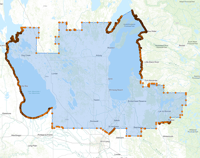
Selkirk-Interlake-Eastman Riding Description
The boundaries of Selkirk-Interlake-Eastman can be described as the region of Manitoba north of Winnipeg and located in between and around Lake Manitoba and Lake Winnipeg. The riding includes the Rural Municipalities of: Pinawa, Lac Du Bonnet, Alexander, Brokenhead, St. Clements, St. Andrews, Rockwood, Woodlands, St. Laurent, Armstrong, Gimli, Bifrost, Fisher, Siglunes, Eriksdale and Coldwell.
Changes Made to the Selkirk-Interlake-Eastman Riding
Compared to the other ridings I've modified in my proposal to the committee the riding of Selkirk-Interlake-Eastman has quite a few changes when compared to the other ridings. The goal here in Selkirk-Interlake-Eastman was to balance out the high populations in the Provencher and Portage - Lisgar ridings bringing all 3 ridings within the +/- 5% tolerance set out by the committee. To balance out the populations the R.M of Woodlands was added and the R.M of Cartier removed as stated in the changes to Portage - Lisgar. However, more changes were made elsewhere like in the North of the riding where the R.M of Grahamdale was entirely removed to avoid splitting the R.M in half. Lastly, the R.M of Whitemouth was removed from the Riding and added back to Provencher. This was done to increase the population of Provencher slightly but most importantly to bring the Selkirk-Interlake-Eastman riding within the +/- 5% tolerance set by the committee. With these changes factored in, the new population of the Selkirk-Interlake-Eastman riding is 99485 people or 3.77% above the mean population of 95868 people per riding.
| Riding Name | Old Riding Population | Old Deviation from Provincial Average | New Riding Population | New Deviation from Provincial Average | Change In Population From Old Riding |
|---|---|---|---|---|---|
| Churchill-Keewatinook Aski | 81258 | -15.24% | 93835 | -2.12% | 12577 |
| Dauphin-Swan River-Neepawa | 89503 | -6.64% | 90569 | -5.53% | 1066 |
| Selkirk-Interlake-Eastman | 101373 | 5.74% | 99485 | 3.77% | -1888 |
| Brandon-Souris | 89812 | -6.32% | 100601 | 4.94% | 10789 |
| Portage-Lisgar | 100417 | 4.75% | 100220 | 4.54% | -197 |
| Provencher | 109445 | 14.16% | 99344 | 3.63% | -10101 |
| Winnipeg West (formerly CSJAH) | 84767 | -11.58% | 97000 | 1.18% | 12233 |
| Winnipeg North | 101221 | 5.58% | 92190 | -3.84% | -9031 |
| Winnipeg Centre | 87499 | -8.73% | 93365 | -2.61% | 5866 |
| Winnipeg South Centre | 94803 | -1.11% | 98183 | 2.41% | 3380 |
| Winnipeg South | 113370 | 18.26% | 95414 | -0.47% | -17956 |
| Kildonan- St. Paul | 91480 | -4.58% | 93501 | -2.47% | 2021 |
| Elmwood- Transcona | 101691 | 6.07% | 98109 | 2.34% | -3582 |
| Saint-Boniface - Saint Vatal | 95514 | -0.37% | 98751 | 3.01% | 3237 |