
Fredericton – Existing boundaries
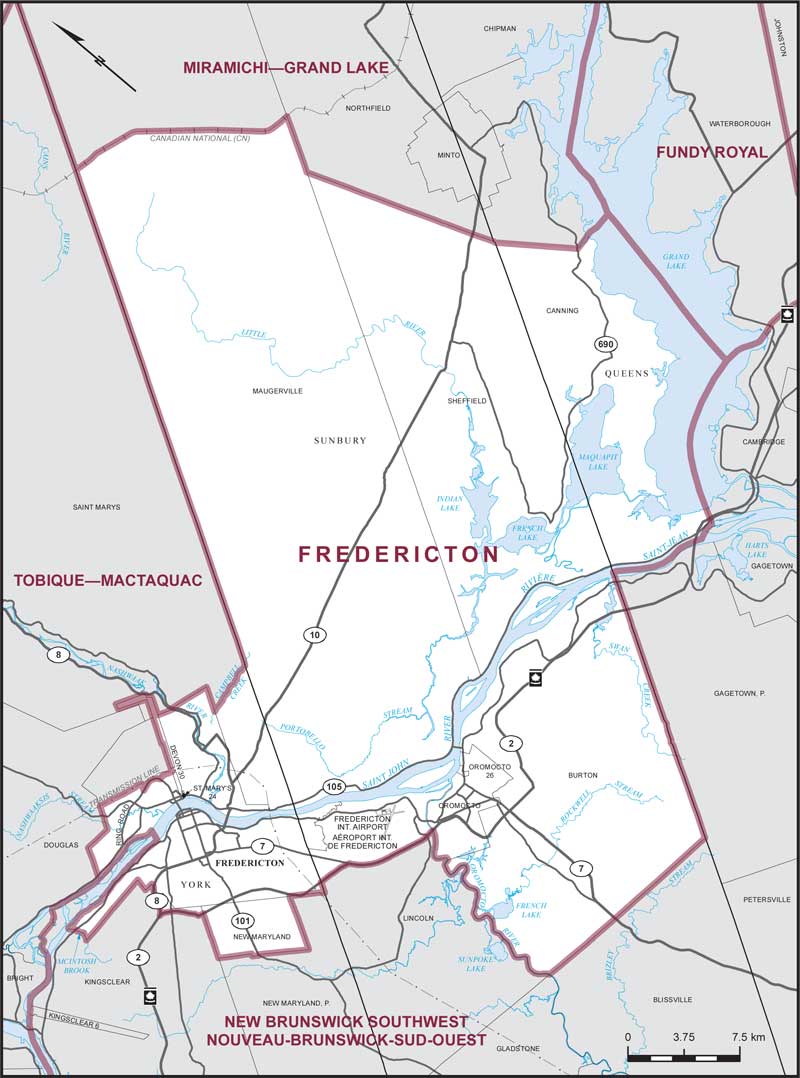
Consisting of:
- (a) that part of the City of Fredericton lying southerly and easterly of a line described as follows: commencing at the intersection of the northerly limit of the City of Fredericton and the westerly boundary of Devon Indian Reserve No. 30; thence southwesterly along the boundary of said Indian reserve and its production to the Two Nations crossing; thence northwesterly and westerly along said crossing to Ring Road; thence generally northwesterly and westerly along said road to Brookside Drive; thence northeasterly along said drive to a transmission line lying immediately north of the West Hills crossing; thence northwesterly along the transmission line to the westerly limit of said city;
- (b) that part of the County of York comprised of:
- (i) the Village of New Maryland;
- (ii) Devon Indian Reserve No. 30 and St. Mary's Indian Reserve No. 24;
- (iii) that part of the Parish of Saint Marys lying southerly of Campbell Creek;
- (iv) that part of the Parish of Kingsclear lying easterly of a line described as follows: commencing at the intersection of the eastbound lane of Highway No. 8 and the westerly limit of the City of Fredericton; thence generally southwesterly along said highway to its intersection with the eastbound lane of Highway No. 2 (Trans-Canada Highway); thence southeasterly along said highway to the southeasterly limit of the Parish of Kingsclear;
- (c) that part of the County of Sunbury comprised of:
- (i) the Town of Oromocto;
- (ii) Oromocto Indian Reserve No. 26;
- (iii) the parishes of Burton and Sheffield;
- (iv) that part of the Parish of Lincoln lying northerly of the eastbound lane of Highway No. 2 (Trans-Canada Highway);
- (v) that part of the Parish of Maugerville lying southwesterly of the Canadian National Railway; and
- (d) that part of the County of Queens comprised of that part of the Parish of Canning lying southwesterly of a line described as follows: commencing at the intersection of the northeasterly limit of the Parish of Sheffield with the northwesterly limit of the Parish of Canning; thence southeasterly in a straight line to the intersection of Highway No. 690 with an unnamed brook lying some 80 metres northeasterly of Pondstream Road; thence southerly and easterly along said brook to Grand Lake; thence generally easterly along said lake to the easterly limit of said parish.