
Fundy Royal – Existing boundaries
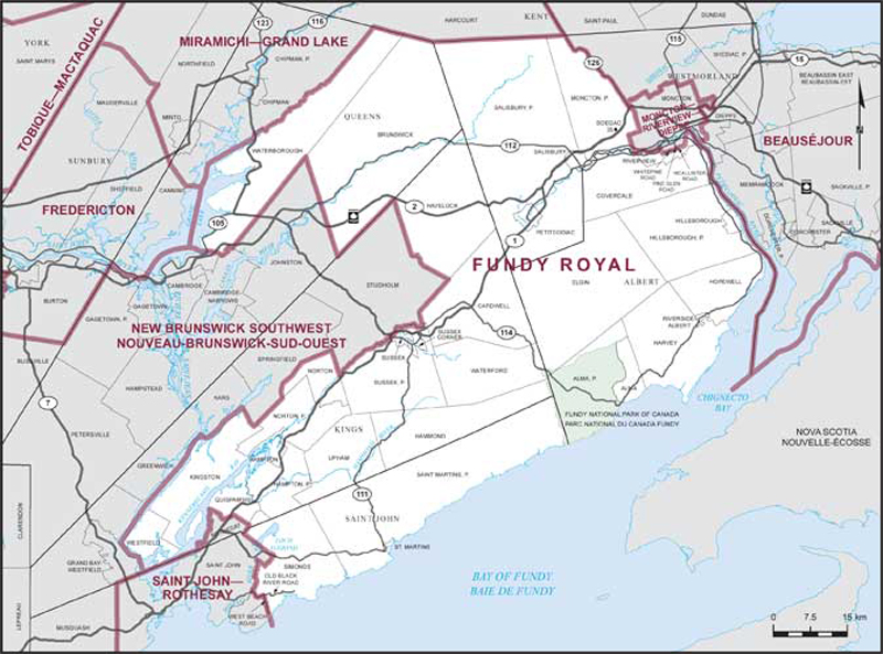
Consisting of:
- (a) the County of Albert, excepting that part of the Town of Riverview described as follows: commencing at the intersection of the Petitcodiac River with the brook known locally as Gray’s Brook; thence generally southeasterly along the most westerly branch of said brook to the westerly production of Whitepine Road; thence easterly along said production and Whitepine Road to Pine Glen Road; thence northerly along Pine Glen Road to McAllister Road; thence easterly along McAllister Road to its most southeasterly corner; thence easterly along the production of said road to the New Brunswick Power Corporation transmission line; thence generally northerly along said line and its production to the rear baseline of the lots fronting on the western right-of-way of Point Park Drive; thence northerly along said rear baseline and its projection to the Petitcodiac River; thence generally southwesterly along said river to the point of commencement;
- (b) the County of Kings, excepting:
- (i) the towns of Grand Bay-Westfield and Rothesay;
- (ii) the parishes of Greenwich, Kars and Studholm;
- (iii) the Parish of Springfield, excepting that part of the Village of Norton lying within said parish;
- (iv) that part of the Parish of Westfield lying northerly and westerly of the Saint John River;
- (c) that part of the County of Queens comprised of the parishes of Brunswick and Waterborough;
- (d) that part of the County of Saint John comprised of:
- (i) the Village of St. Martins;
- (ii) the Parish of Saint Martins;
- (iii) that part of the Parish of Simonds lying northeasterly of a line described as follows: commencing at the intersection of Old Black River Road and the easterly limit of the City of Saint John (that is to say, the Mispec River); thence generally southeasterly and easterly along said road to West Beach Road; thence southerly along said road to latitude 45°13'44"N; thence southerly in a straight line to a point in the Bay of Fundy lying at latitude 45°12'31"N and longitude 65°50'39"W; and
- (e) that part of the County of Westmorland comprised of:
- (i) the villages of Petitcodiac and Salisbury;
- (ii) the Parish of Salisbury;
- (iii) that part of the Parish of Moncton lying westerly of a line described as follows: commencing at the intersection of the northerly limit of said parish and Highway No. 126; thence generally southeasterly along said highway to Homestead Road; thence northeasterly along said road to the westerly limit of the City of Moncton; thence generally southerly along said limit to the Petitcodiac River;
- (iv) Soegao Indian Reserve No. 35.