
Miramichi–Grand Lake – Existing boundaries
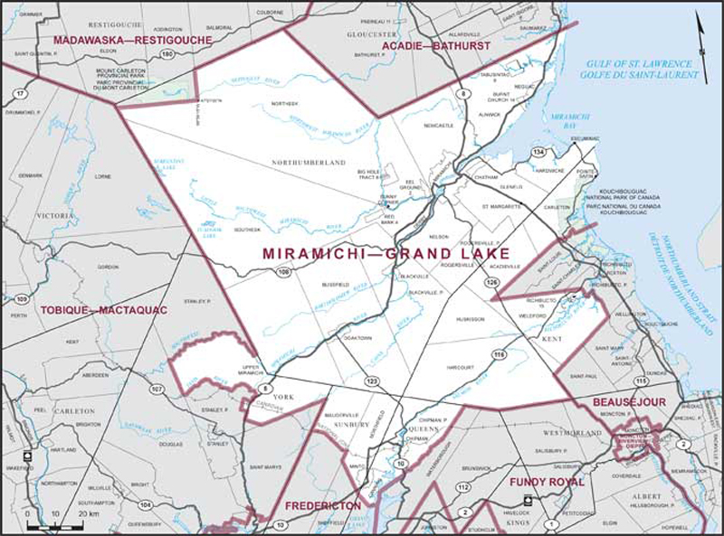
Consisting of:
- (a) the County of Northumberland, excepting that part lying westerly and northerly of a line described as follows: commencing at the intersection of the northerly limit of said county and the westerly limit of the Parish of Balmoral; thence southerly along the production of the westerly limit of said parish to the Mount Walker peak, lying at approximate latitude 47°21'00"N and longitude 66°39'15"W; thence due west to the westerly limit of said county;
- (b) that part of the County of Kent comprised of:
- (i) that part of the Village of Rogersville lying within said county;
- (ii) the parishes of Acadieville, Carleton, Harcourt, Huskisson and Weldford;
- (iii) Richibucto Indian Reserve No. 15;
- (c) that part of the County of Queens comprised of:
- (i) the Village of Chipman;
- (ii) the Parish of Chipman;
- (iii) that part of the Village of Minto lying within said county;
- (iv) that part of the Parish of Canning lying northeasterly of a line described as follows: commencing at the intersection of the northeasterly limit of the Parish of Sheffield and the northwesterly limit of the Parish of Canning; thence southeasterly in a straight line to the intersection of Highway No. 690 and an unnamed brook lying some 80 metres northeasterly of Pondstream Road; thence southerly and easterly along said brook to Grand Lake; thence generally easterly along said lake to the easterly limit of said parish;
- (d) that part of the County of Sunbury comprised of:
- (i) the Parish of Northfield;
- (ii) that part of the Parish of Maugerville lying northeasterly of the Canadian National Railway;
- (iii) that part of the Village of Minto lying within said county; and
- (e) that part of the County of York comprised of that part of the Rural Community of Upper Miramichi lying within said county.