
Moncton–Riverview–Dieppe – Existing boundaries
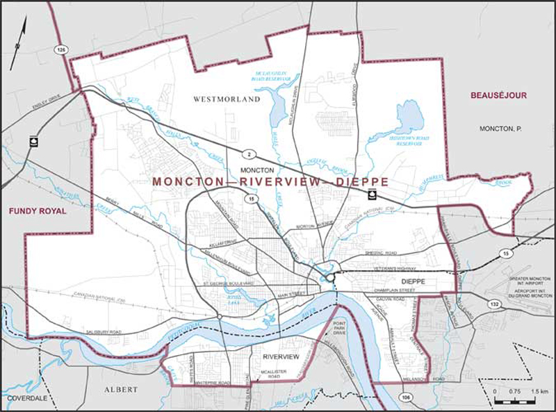
Consisting of:
- (a) that part of the County of Westmorland comprised of:
- (i) that part of the City of Moncton described as follows: commencing at the intersection of the easterly limit of said city and the eastbound lane of Highway No. 2 (Trans-Canada Highway); thence westerly along said highway to Harrisville Boulevard; thence southeasterly along said boulevard to the southerly limit of said city; thence generally southwesterly, northerly and easterly along the limits of said city to the point of commencement;
- (ii) that part of the City of Dieppe described as follows: commencing at the intersection of the northerly limit of said city and Dieppe Boulevard; thence southerly along said boulevard to Champlain Street; thence westerly along said street to Pascal Avenue; thence southerly along said avenue to Gauvin Road; thence westerly along said road to Thomas Street; thence generally southerly along said street and Centrale Street to Melanson Road; thence westerly along said road and its production to the westerly limit of said city; thence northwesterly and easterly along the limits of said city to the point of commencement; and
- (b) that part of the County of Albert comprised of that part of the Town of Riverview described as follows: commencing at the intersection of the Petitcodiac River with the brook known locally as Gray's Brook; thence generally southeasterly along the most westerly branch of said brook to the westerly production of Whitepine Road; thence easterly along said production and Whitepine Road to Pine Glen Road; thence northerly along Pine Glen Road to McAllister Road; thence easterly along McAllister Road to its most southeasterly corner; thence easterly along the production of said road to the New Brunswick Power Corporation transmission line; thence generally northerly along said line and its production to the rear baseline of the lots fronting on the western right-of-way of Point Park Drive; thence northerly along said rear baseline and its projection to the Petitcodiac River; thence generally southwesterly along said river to the point of commencement.