
Addendum to the Report Disposition of Objections – British Columbia
Introduction
This is the Commission's Response to objections filed by Members of Parliament with the Standing Committee on Procedure and House Affairs. Ten specific objections to the Report's electoral boundaries were filed. One objection concerns electoral boundaries on Vancouver Island. Eight objections concern electoral boundaries in the Lower Mainland Fraser Valley region. Of these, seven are individual objections and one is a joint submission from two Members of Parliament. Additionally, 12 Members of Parliament filed a joint submission with respect to the Lower Mainland Fraser Valley variously supporting individual objections, or supporting individual objections conditionally. One objection concerns electoral boundaries
in the Southern Interior region. There are nine objections to names proposed for electoral districts—some included with an objection to electoral boundaries. We address all issues of names after the objections to electoral boundaries.
We have considered the Committee's views on the objections, both the majority and the dissenting opinions, and applied ourselves to each of the objections individually with the aid of our geographer Mr. Lorenzetti, in the context of the changes collectively proposed in our Report dated February 7, 2023. We have sought to keep a consistent approach throughout the ultimate dispositions for the entire province, mindful of the local experiences informing the objections filed.
Our Response to the objections takes into account the particular challenges discussed in the Report—the pattern of uneven population growth revealed in the census and the force of the province's varied and rugged terrain. Combined, these features create an unavoidable chain reaction from any adjustment in electoral district boundaries.
Our Report accepted many of the thoughtful criticisms and suggestions provided by members of the public in the public hearing process. Foremost, these representations addressed the choice of river crossings and municipal considerations. Implementing changes in response to public input necessarily required alteration in boundaries of other electoral districts in the concerned region. The result was a Report much changed from the Proposal that we believe provides for effective representation in all electoral districts. We understand, however, that new boundaries described in the Report have not been open to public consultation. Most of the objections now before us address boundary changes that appear for the first time in the Report. With this in mind, we have given the objections most careful and respectful scrutiny, accepting some but not all of the Members' submissions.
Several of the objections invoke expected growth, great or modest, that may be experienced in the future. We have not taken such forecasts into account, on the view that they are outside our mandate established in the Act instructing us on the factors we may consider. Predictions of the future are not on that list.
As a point of clarification, certain comments have been made in the objections that the Report has divided Indigenous lands into different electoral districts. Each Indian Band was mailed a letter enclosing information about the redistribution process, the Commission's Proposal, and the public input process, with the opportunity to comment. The circumstances of Indigenous lands are complex, but Indian reserves have definition and we have sought to locate those lands within one electoral district. In the places where that objective has not been met, the Report retained current electoral boundaries that separated only an area without census population from occupied communities and was not the subject of adverse comment in the public hearing process.
Electoral District Boundary Objections
Joint Submissions
In addition to the seven individual submissions concerning electoral boundaries in the Lower Mainland Fraser Valley region, a joint objection filed by Peter Julian, Member for New Westminster—Burnaby, and Bonita Zarrillo, Member for Port Moody—Coquitlam, addresses specific boundaries impacting their current electoral districts.
The 12 -signatory submission is signed by: John Aldag, Member for Cloverdale—Langley City; Parm Bains, Member for Steveston—Richmond East; Terry Beech, Member for Burnaby North—Seymour; Sukh Dhaliwal, Member for Surrey—Newton; the Honourable Hedy Fry, P.C., Member for Vancouver Centre; Ken Hardie, Member for Fleetwood—Port Kells; Ron McKinnon, Member for Coquitlam—Port Coquitlam; Wilson Miao, Member for Richmond Centre; Taleeb Noormohamed, Member for Vancouver Granville; the Honourable Carla Qualtrough, P.C., Member for Delta; Randeep Sarai, Member for Surrey Centre; and the Honourable Jonathan Wilkinson, P.C., Member for North Vancouver.
The Committee explained the 12-signatory joint submission:
The signatories ... indicated that they supported members who objected to the proposed boundaries of their own ridings, provided that their proposals did not affect the non-Vancouver ridings named in the joint objection. Further, the signatories of the joint objection asked that any objection affecting the named non-Vancouver ridings be first accepted by their affected neighbouring member of Parliament.
...
The signatories ... were generally satisfied with several of the ridings proposed in the Commission's Report. ...
As for the district of Steveston—Richmond East, Mr. Bains indicated that he was satisfied with the proposal and generally accepted the proposed boundaries. However, in the joint objection, he stated that he could work with Mr. Miao on minor changes affecting both their ridings.
For Vancouver Centre, the objection stated that Dr. Fry was relatively satisfied with the proposed boundaries but filed a separate objection specifically for Granville Island.
Lastly, the joint objection noted that Mr. Weiler reiterated concerns that were heard during the public hearings and that he had filed a separate objection about them. The signatories ... indicated that they are prepared to support his proposal, for West Vancouver—Sunshine Coast—Sea to Sky Country, in which part of the eastern boundary set out in the Report to 21st Street under the highway would be moved, provided that this change did not affect the eastern boundary of North Vancouver or the proposed boundaries of the riding of Burnaby North—Seymour. According to the signatories, placing the boundary at 15th Street instead of 21st Street would be a feasible option, as this is the boundary that was presented by the Commission in its initial Proposal.
We address the ten specific objections to electoral boundaries first and then objections to names proposed. In responding to the objections relating to the Lower Mainland Fraser Valley region, we have had regard to the 12-signatory joint submission and its limiting statements. This response is organized roughly west to east in its consideration of the boundary objections, agglomerating them by electoral districts.
Nanaimo—Ladysmith, Cowichan—Malahat—Langford, Courtenay—Alberni
The Honourable Kerry-Lynne D. Findlay, P.C., Member for South Surrey—White Rock, filed an objection regarding the Report's electoral boundaries for Nanaimo—Ladysmith. By those boundaries, Lantzville and an adjoined area in the north of Nanaimo are moved from Nanaimo—Ladysmith to join Courtenay—Alberni.
Ms. Findlay proposes that in place of the Report's boundary change, Lantzville remain in Nanaimo—Ladysmith and that a southern part of Nanaimo—Ladysmith, such as Saltair and surrounding area, be assigned to Cowichan—Malahat—Langford. By this suggestion, the Commission understands Ms. Findlay includes the Nanaimo lands adjoining Lantzville in her suggestion. In her objection Ms. Findlay notes the strong connections between the district of Lantzville and the City of Nanaimo, and also observes that there is a shared community of interest between Saltair and Duncan, a community located in Cowichan—Malahat—Langford.
The Commission has identified Nanaimo—Ladysmith as the focal point, mid-Island, of high population growth. The result of the growth is a census population for Nanaimo—Ladysmith that is considerably over both the provincial quota and the regional average. The Commission concluded that this divergence needs to be addressed and the district's under-representation reduced, in the interests of electoral equality, by spreading the area's population into more than one electoral district.
The Commission has closely re-examined each of the two alternatives, shifting the northern boundary southward, and shifting the southern boundary northward. Moving the southern boundary northward by assigning the Saltair region south of Ladysmith to Cowichan—Malahat—Langford will not sufficiently balance a return of Lantzville and north Nanaimo to Nanaimo—Ladysmith. Yet deeper changes to the southern boundary to adequately lower the population of Nanaimo—Parksville will create a chain response with significant disruption to other electoral districts south of the Malahat.
This consideration and the high population circumstance of Nanaimo—Ladysmith lead us to conclude that we cannot give effect to this objection. The three electoral districts involved in this objection should remain configured as set out in our Report.
Howe Sound—West Vancouver
The Honourable Patrick Weiler, P.C., Member for West Vancouver—Sunshine Coast—Sea to Sky Country, filed an objection to the proposed change to the eastern boundary of his electoral district.
The Proposal designated 15th Street as the new eastern boundary for the district. Public submissions expressed concern that a boundary along 15th Street would divide the neighbourhood of Ambleside. On considering those submissions, the Commission had the Report amend the boundary westward to 21st Street. Mr. Weiler proposes instead that the boundary be changed eastward to 11th Avenue, to avoid dividing West Vancouver between the two main commercial areas of Ambleside and Dundarave, and to avoid dividing a cohesive residential area in those neighbourhoods. He acknowledges that this would leave the population in the electoral district relatively high, but notes the population would be generally consistent with the average population of the electoral districts in the Vancouver Island region.
We have searched for other alternatives, accepting the predominant message delivered in the public submissions that dividing Ambleside by using 15th Street as the boundary, should be avoided if another reasonable boundary is available. In that search, we closely examined the suggestion of using 11th Street as the eastern boundary, aware that whether and where to divide any community between electoral districts is a serious matter. However, our view must be broad. The census population of West Vancouver—Sunshine Coast—Sea to Sky Country is considerably above the provincial quota and the populations of its two nearby electoral district neighbours, North Vancouver and Burnaby North—Seymour. A movement westward of the electoral district's boundary with North Vancouver is the only available practical route to reducing this variance. Such reconfiguration inevitably will be felt by all three districts.
Addressing specifically Mr. Weiler's proposal of using 11th Street as the eastern boundary, we see this will leave this electoral district with the highest population in the Lower Mainland Fraser Valley region, at a level still quite discrepant from its neighbours. This will prompt, on the principle of electoral fairness, a further boundary adjustment between North Vancouver and North Burnaby—Seymour. While we are urged to look to Vancouver Island for a comparable district population, we see the near neighbours as the appropriate comparators, and not electoral districts on Vancouver Island that, for the reasons explained in the Report, will have the highest regional average populations.
From our re-examination of this boundary, and our search for a reasonable alternative to reduce this district's unduly high population, we consider the Report's location of the boundary at 21st Street is the best resolution of this dilemma. The configuration of this electoral district and, consequently, the configuration of the other two North Shore electoral districts remain as in the Report.
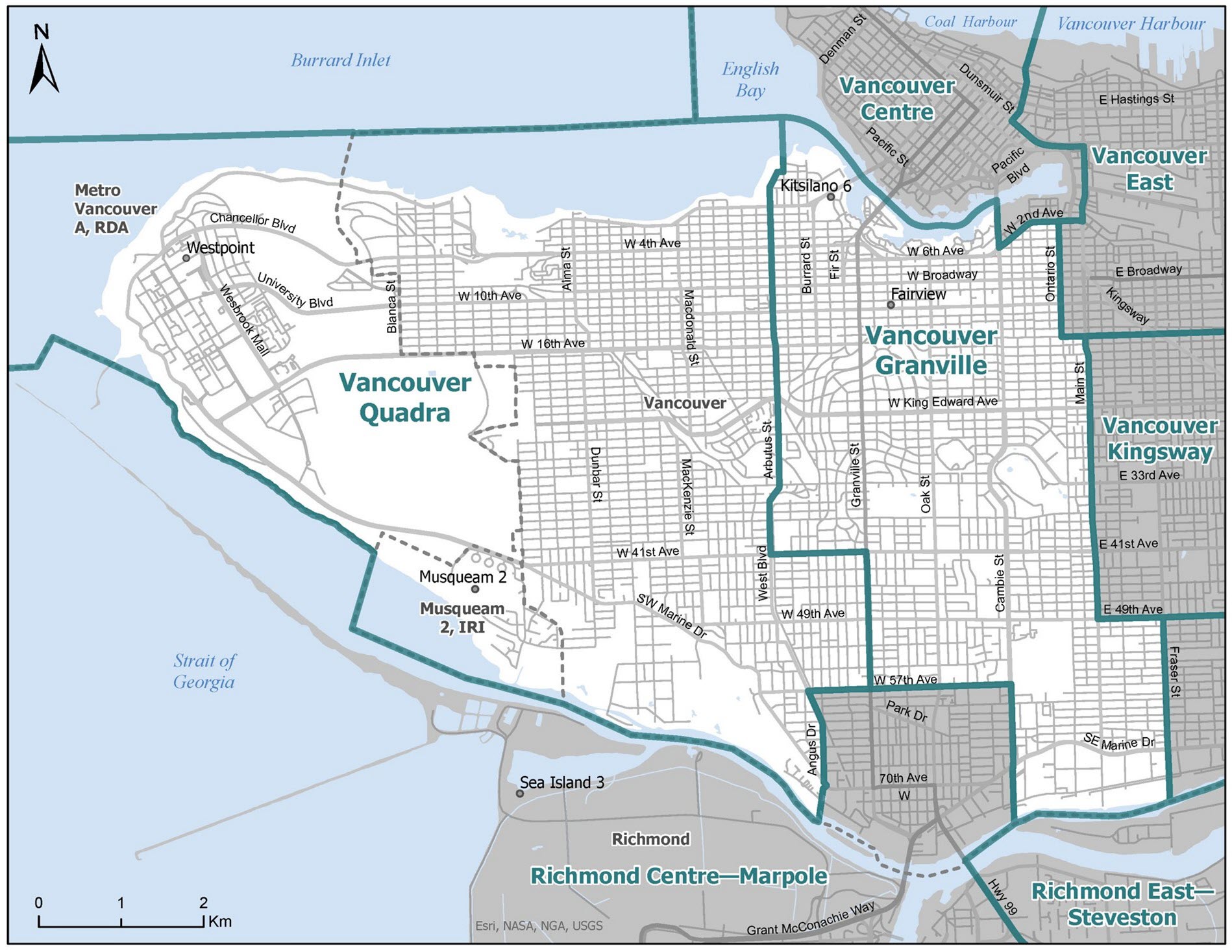
Vancouver Arbutus, Vancouver West Broadway
The Honourable Joyce Murray, P.C., Member for Vancouver Quadra, filed an objection to the Report's reconfiguration of the two electoral districts on the west side of Vancouver that are currently oriented north-south. The Report adjusts the boundary for them east-west into two electoral districts named Vancouver West Broadway and Vancouver Arbutus. Ms. Murray submits that the reconfiguration unnecessarily splits the activities of the Indigenous Musqueam community into multiple ridings and is contrary to the established pattern.
We recognize that the changes made in the Report's redesign of these electoral districts are significant. While the reconfiguration does not sever Musqueam Indian Reserves differently from the now-existing boundaries, there is some force to the submission that there is no pressing need at this time to reorient these electoral districts by creating electoral disturbance to the existing communities of interest. We have reconsidered the boundaries for these two electoral districts drawn in our Report and are returning them to their current orientation, with some modifications for consistency with decisions made in respect of other Vancouver electoral districts, and for balance.
The redrawn boundaries of these two districts reach into surrounding bodies of water, affecting the reach into those same bodies of water of Vancouver Centre and Howe Sound—West Vancouver (to be renamed as shown below), requiring consequent adjustments to the descriptions of those electoral districts.
Boundaries of Vancouver Quadra and Vancouver Granville
Richmond Centre—Marpole, Vancouver Arbutus, Vancouver Kingsway, Vancouver Fraserview—South Burnaby, and Vancouver West Broadway
Four Members of Parliament filed individual objections to the reconfiguration of their current electoral districts to create these four districts described in the Report: Mr. Miao, Mr. Noormohamed, Don Davies, Member for Vancouver Kingsway, and the Honourable Harjit Sajjan, P.C., Member for Vancouver South. Mr. Miao and Mr. Noormohamed are also part of the 12-signatory joint submission.
The objections note that the Report's proposal for the current electoral districts is much changed from the Proposal and presents a significant reconfiguration of electoral districts that has not been exposed to public comment. This is so, but it is a consequence of the process enacted by Parliament that requires a Commission to revisit its proposal after public hearings.
The Proposal had reconfigured an electoral district crossing the south arm of the Fraser River, joining lands in Richmond to lands in Delta, and had increased the number of electoral districts that included Burnaby lands. In response to strong submissions made by the public, principally on the need for, and a proposed site for, a crossing of the Fraser River within an electoral district, and the number of electoral districts for Burnaby residents, the Commission revisited the Proposal, seeking a better solution to both issues.
From that re-examination, we concluded that crossing the north arm of the Fraser River to include the Marpole area in an electoral district with Richmond lands, in place of crossing the south arm as the Commission had proposed, produced a more advantageous, less disruptive electoral district design that, on a broad view, was significantly improved from the Proposal. We saw the Report's reconfiguration of incorporating this Fraser River Marpole area of Vancouver into a Richmond electoral district as beneficial. It reduces the variance in population for the two Richmond electoral districts compared to both the provincial quota and the regional average, facilitates reduction of the number of electoral districts that encompass lands in Burnaby, and allows for improvement in the electoral boundaries between Surrey and Delta. Reorganizing the boundaries in this way led us to re-situate portions of Vancouver bounded by Main Street and Knight Street, and 41st and 49th Avenues in the Sunset neighbourhood.
The objections of these four Members address boundary reconfigurations affecting the Marpole and the Sunset neighbourhoods.
Both Mr. Miao and Mr. Noormohamed question the Commission's decision to cross the north arm of the Fraser River so as to bring Marpole and most of the current electoral district of Richmond Centre together in one electoral district. They would have the north arm of the Fraser River stand as the boundary between the two electoral districts to better recognize the communities of interest in these areas and their historical patterns.
We have examined again the general concept of a river crossing and the viability of crossing the north arm, and looked again at this area in the broader picture of adjacent and nearby electoral districts. We cannot ignore the circumstance that both current Richmond electoral districts are far below the provincial quota while others in the region are considerably over-quota, such that hard choices must be made to address the undue under-representation in other electoral districts in the region.
The Commission concludes that there is no practical alternative, given the geography of this area and the variances of population, to crossing the Fraser River somewhere. On review, it appears to the Commission that crossing the north arm is a good choice. It has the advantage of strong transportation links over the Fraser River, a shared history between Richmond and Vancouver on the river, and electoral history (albeit dated) of shared federal representation. It is, we consider, a stronger choice than crossing the south arm, brings advantages of simplifying boundaries in west Surrey with Delta, and by creating population room on the north side of the Fraser River, allowed for adjustment to electoral boundaries that ultimately has the effect of lowering the number of Burnaby's shared electoral districts. We are confident this reconfigured electoral district will provide for effective representation of its residents. With these considerations in mind, the boundary including the Marpole area within Richmond Centre—Marpole set out in the Report is unchanged.
Mr. Davies, Mr. Noormohamed, and Mr. Sajjan filed objections to the reconfigured electoral boundaries in Vancouver from Main Street to Knight Street and 41st Avenue to 49th Avenue
set out in the Report. This area is relevant to the current electoral districts the Members represent—Vancouver Granville, Vancouver Kingsway, and Vancouver South. Currently the three districts are all under the provincial quota and the regional average. By the Report and the amendments to Vancouver Granville discussed above, all three electoral districts are brought nearer to the quota, helping with the population imbalances elsewhere in the region.
The Report created a newly configured Vancouver Fraserview—South Burnaby electoral district encompassing much of current Vancouver South and Burnaby South. On the west, this electoral district starts at the edge of the Marpole area just discussed. Significant to the Members' objection, Vancouver Fraserview—Burnaby South does not include the area bounded by Main and Knight Streets and 41st and 49th Avenues. That area is reassigned to Vancouver Kingsway (which in turn does not include lands in Burnaby as had been set out in the Proposal). In the Members submission, these changes unduly split a community of interest loosely described as the Punjabi Market and Sunset neighbourhood and is contrary to historical patterns.
The Commission has found this area challenging. In what Mr. Sajjan describes as "one of the most diverse neighbourhoods of Vancouver" a change of boundaries will inevitably be disruptive, yet the residents of the area are entitled to reasonably equal representation in the interests of electoral fairness, as are their neighbours.
Mr. Davies proposes that an area now in Vancouver Granville, two blocks wide from Main Street to Ontario Street,16th Avenue to 41st Avenue, be added to Vancouver Kingsway, and the southern boundary of Vancouver Kingsway be an unbroken expanse of 41st Avenue, so as to exclude the area bounded by Main Street to Knight Street, and 41st Avenue to 49th Avenue.
Mr. Noormohamed likewise proposes that the boundary generally between electoral districts in the eastern and western portions of Vancouver follow Ontario Street, and expresses concern that the Report's boundaries in the Main Street to Knight Street, 41st Avenue to 49th Avenue area will adversely affect the Sikh and Punjabi associations and community hubs centred in that area.
Mr. Sajjan presents a review of the history of the Sunset neighbourhood. In his objection, he asks for change, focussing on the effect of a boundary along Fraser Street and noting that the boundaries separate an area that has an historical community of interest into three electoral districts. Mr. Sajjan proposes an alternative design, assigning lands differently for Vancouver Kingsway, Vancouver South and Vancouver district to the west.
The Commission has considered in detail the Members' proposals, and a myriad of alternatives to the proposed boundaries. We have not found, including in the suggestions, alternative boundaries for this area we can adopt that maintain a reasonable balance of population between electoral districts, and when seen in the context of the significant improvements coming with the design of Richmond Centre—Vancouver Marpole, support a redesign of these boundaries.
In the end, all we can say on this question is that the Commission has reviewed the alternatives and sought other designs, without improvement in the larger context of our province-wide mandate. Ultimately, we have not found a disposition we consider better than this and we are satisfied that in the context of this urban area, the residents affected will be provided effective representation. With appreciation for the objections made, we confirm the electoral district boundaries set out in the Report for this area.
Vancouver Centre
Dr. Fry, a signatory to the large joint submission, filed a separate objection addressing the assignment of Granville Island to an electoral district on the south side of False Creek. She observes that Granville Island (with less than two dozen residents) has long been part of Vancouver Centre.
Of the six Vancouver electoral districts, Vancouver Centre is the only one significantly over-quota and under-represented. This led us to assign a portion of the south side of False Creek to the electoral district that will be known as Vancouver Granville. This change removed Vancouver Centre's only land access to Granville Island; all Granville Island's land access will connect to Vancouver Granville. On the principle of contiguity, we accordingly reassigned Granville Island to Vancouver Granville. Considering this principle, the boundaries remain unchanged.
New Westminster—Burnaby—Maillardville, Port Moody—Coquitlam
The joint submission of Mr. Julian and Ms. Zarrillo addresses three areas in the reconfiguration of their current electoral districts. The first is the area in the City of Coquitlam comprising Maillardville and lands in the Burquitlam area, currently within Port Moody—Coquitlam. The second is the Westwood Plateau area currently in Coquitlam—Port Coquitlam, and lands including Anmore and Belcarra currently in Port Moody—Coquitlam. The third is part of Burnaby's Edmonds area currently in New Westminster—Burnaby.
The proposed changes to these electoral districts address variances in populations in the affected and nearby electoral districts. Both the current New Westminster—Burnaby and Port Moody—Coquitlam electoral districts are somewhat under-quota. Their neighbour, Coquitlam—Port Coquitlam, however, is one of the high-growth electoral districts in the region and is significantly over-quota.
The Commission considers that alone, and compared to its neighbours, the degree of under-representation of Coquitlam—Port Coquitlam resulting from its high population calls for boundary adjustment to preserve electoral fairness. In the Proposal the Commission addressed these and other regional population imbalances. As a solution, the Commission proposed an electoral district joining New Westminster and Surrey by crossing the Fraser River, and an electoral district joining Coquitlam to Pitt Meadows by crossing the Pitt River. That proposal was met with extensive public dissatisfaction and the numerous forthright submissions addressing this area prompted the Commission to look for other solutions to the area's population imbalances. The result is the Report's assignment of a portion of lands in the Westwood Plateau from Coquitlam—Port Coquitlam to Port Moody—Coquitlam, and the assignment of lands in the southern part of Port Moody—Coquitlam to a reconfigured New Westminster—Burnaby electoral district. For population balance, the Report also reconfigured the Edmonds area, an area of Burnaby long divided between electoral districts.
Addressing the changes for Maillardville, the Members say that moving that area and a neighbouring area in Coquitlam to the New Westminster-centred district is not consistent with the historical pattern of the area or communities of interest, and connects neighbourhoods that are not closely associated. In respect of the Westwood Plateau, Ms. Zarrillo proposes reversing the Report's assignment of part of the Westwood Plateau out of Coquitlam—Port Coquitlam to Port Moody—Coquitlam, as well as joining Anmore, Belcarra and associated areas to the Westwood Plateau, effectively moving the current Port Moody—Coquitlam and Coquitlam—Port Coquitlam boundary westward.
In addressing the Edmonds area, Mr. Julian says the Report unduly divides the Edmonds neighbourhood, and asks that it be kept in its current electoral district of New Westminster—Burnaby.
Here, too, we have searched for alternatives to the Report's boundaries reconfigurations that will level the electoral district populations to a reasonable variance. The area encompassed in these districts is constrained by mountains and two rivers, the Pitt and the Fraser. Even with that geography, which places physical barriers between neighbourhoods, we are satisfied that the transportation corridors allow for reasonable access within the districts. We are also satisfied that there is a sufficient measure of common interests and shared experience to support the electoral districts proposed.
We acknowledge the objections raised to the Report's electoral map for this area, yet we have found no arrangements for this area, within the constraints of the rivers, that will provide a better disposition to the weighty population pressures. The boundaries in the Report for these districts remain.
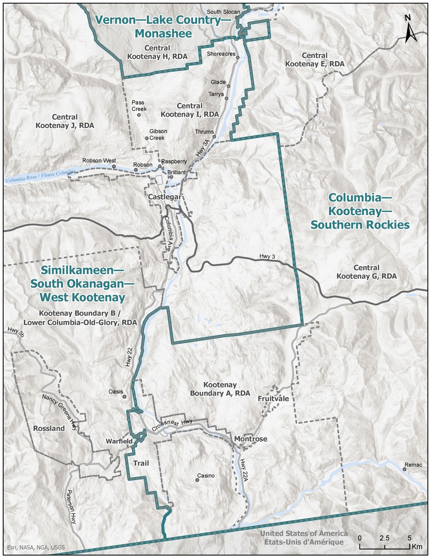
West Kootenay—Columbia, Similkameen—West Kootenay, Vernon—Monashee
Richard Cannings, Member for South Okanagan—West Kootenay, filed an objection to the reconfiguration of electoral districts touching on lands currently within his electoral district.
The census for the current Southern Interior electoral districts revealed several districts with populations unduly over the provincial quota. The Commission determined that British Columbia's single additional electoral district should be allocated to the Southern Interior region to address the region's over-quota, under-representation circumstance. Necessarily, fitting an additional electoral district into the region required reconfiguration of all its existing six electoral districts.
The Report noted the complexity encountered in configuring electoral districts in the Southern Interior. The complexity comes from the steep terrain, narrow valleys, and sparse population in much of the region. The larger communities are, as a rule, surrounded by smaller communities, with that nucleus of population often a considerable distance from the next nucleus of population, in the way bunch grass populates grasslands. The area Mr. Canning addresses has all these characteristics.
The Commission's first re-design for the Southern Interior put forward in the Proposal was met with mixed reaction. Taking the public's responses and suggestions into account, the Commission made extensive changes to the Proposal's electoral map. We will say that in this complicated region, the vast Kootenays-Boundary Country area posed its own challenge by reason of geography.
The Report significantly re-designed the electoral map with counter-clockwise changes relative to the boundary changes that Mr. Canning addresses. It assigned areas now in the northern part of Kootenay—Columbia, along with a portion of North Okanagan—Shuswap, to a district oriented along the Trans-Canada Highway from Kamloops to the provincial border, and moved the western boundary of Kootenay—Columbia so as to include certain smaller communities in the Castlegar and Trail locales within renamed Columbia—Kootenay—Southern Rockies.
The Report then reconfigured most of the remainder of North Okanagan—Shuswap by joining Lake Country in an electoral district with Vernon that extends through the Monashee range to Nakusp and areas in the Slocan Valley. The Commission named this district Vernon—Monashee. The Slocan changes took areas away from current South Okanagan—West Kootenay, which has been further reconfigured to include most of the Similkameen area.
Mr. Canning questions the choice of boundary between the reconfigured Similkameen—West Kootenay and Columbia—Kootenay—Southern Rockies districts, the assignment of communities in the Slocan Valley to Vernon—Monashee, and the inclusion of most of the Similkameen in Similkameen—West Kootenay. He also questions the changes involving Kamloops. We take this latter submission as comment only, and not an objection.
In addressing Mr. Canning's objection, the Commission has given detailed consideration to the alternatives available that will keep the populations of the electoral districts affected by the issue roughly level while strengthening some connections between communities closely associated with each other, as suggested by Mr. Canning.
Three areas in the West Kootenay area are particularly noted by Mr. Canning: certain communities in the Slocan Valley, certain communities separated from their nearby larger neighbour, the City of Castlegar, and certain communities separated from their nearby larger neighbour, the City of Trail. On the western side of Similkameen—West Kootenay, Mr. Canning suggests that the Similkameen area be joined to Okanagan Lake West—South Kelowna so as to make population room for the Slocan Valley change he suggests.
There is force to Mr. Canning's submission in respect of the Castlegar and Trail neighbourhoods of communities, and his suggestion can be given effect to strengthen communities of interest without creating undue variance between Similkameen—West Kootenay and Columbia—Kootenay—Southern Rockies. Accordingly, by this Response, we reconfigure the Report's boundaries for the Castlegar and Trail areas by locating the Castlegar neighbourhood of communities within the Similkameen—West Kootenay electoral district, and locating Trail and its neighbour communities to the east within Columbia—Kootenay—Southern Rockies. With these changes the variance between the two districts remains in the same scale, but it becomes Columbia—Kootenay—Southern Rockies that has the greater population.
Reassigning communities in the Slocan Valley assigned to Vernon—Monashee so as to join them to Columbia—Kootenay—Southern Rockies, and reassigning the Similkameen Valley to Okanagan Lake West—South Kelowna are different matters. All in all, these suggestions would unduly distort the population balances in the rest of the Southern Interior and create a more disruptive chain reaction. We have not made these changes.
Modified boundaries of Columbia—Kootenay—Southern Rockies and Similkameen—South Okanagan—West Kootenay
Naming Objections
North Island—Powell River
Rachel Blaney, Member for North Island—Powell River, suggests the North Island—Powell River electoral district be named North Island—qathet to reflect usage of the Indigenous word 'qathet' in the Powell River area.
The name of the electoral district currently identifies its most easterly city in its name. We are conscious there has been a name change in the regional district, but by precedent most district names are not based on regional district naming, nor remove identifying municipal names. For this reason, we leave the name unchanged.
Howe Sound—West Vancouver
Mr. Weiler advocates maintaining the name West Vancouver—Sunshine Coast—Sea to Sky Country. We agree.
Vancouver West Broadway and Vancouver Arbutus
Ms. Murray suggests that the two electoral districts returned to a north-south orientation of Vancouver Quadra and Vancouver Granville bear their current names. We agree.
Vancouver Fraserview—South Burnaby
Mr. Sajjan suggests Vancouver Fraserview—South Burnaby be named either Vancouver South—Burnaby or Vancouver—Burnaby South to reflect the name of the current electoral districts affected by the reconfiguration. In the circumstances of the proportions of the electoral district that are located in each city, we would not prefer one city to the other. For this reason the name is unchanged from the Report.
Cloverdale—Langley City
Mr. Aldag suggests changing the name Cloverdale—Langley City to Cloverdale—Langley City—Sullivan Heights to address the composition of the electoral district. By this Report, the only change to the electoral district is a reassignment of a small area of Sullivan Heights out of the district. The Commission considers that a name change would connote to the public a change to electoral boundaries that has not happened. For that reason, we leave the name unchanged.
Langley Township
Mr. van Popta suggests that the electoral district in the Report, Langley Township, be renamed Langley Township—Fraser Heights. We agree.
Kelowna—Lake Country
Tracy Gray, Member for Kelowna—Lake Country, suggests that the electoral district in the Report, Vernon—Monashee, be renamed to include the name of Lake Country. We agree. The district will be called Vernon—Lake Country—Monashee.
Similkameen—West Kootenay
Mr. Cannings suggests the electoral district in the Report, Similkameen—West Kootenay, be renamed to include 'South Okanagan'. We agree. The district will be called Similkameen—South Okanagan—West Kootenay.
Capilano—North Vancouver
Mr. Wilkinson suggests that the name Capilano—North Vancouver be changed to North Vancouver—Ambleside in the event the Commission keeps 21st Street as its western boundary, as it is doing. We would not replace "Capilano", long associated with a West Vancouver electoral district, but do reorder the name. The electoral district will be called North Vancouver—Capilano.
Conclusion
In summary, the final electoral districts configured by this Commission appear in the table below, and revised maps and descriptions of electoral districts are contained in the Appendices on the following pages.
| Name of Federal Electoral District | Population |
|---|---|
| Abbotsford—South Langley | 116,265 |
| Burnaby Central | 120,734 |
| Burnaby North—Seymour | 119,311 |
| Cariboo—Prince George | 117,160 |
| Chilliwack—Hope | 119,082 |
| Cloverdale—Langley City | 117,050 |
| Columbia—Kootenay—Southern Rockies | 117,132 |
| Coquitlam—Port Coquitlam | 114,460 |
| Courtenay—Alberni | 122,753 |
| Cowichan—Malahat—Langford | 124,115 |
| Delta | 117,734 |
| Esquimalt—Saanich—Sooke | 120,170 |
| Fleetwood—Port Kells | 117,423 |
| Kamloops—Shuswap—Central Rockies | 109,218 |
| Kamloops—Thompson—Nicola | 111,707 |
| Kelowna | 105,736 |
| Langley Township—Fraser Heights | 117,251 |
| Mission—Matsqui—Abbotsford | 118,415 |
| Nanaimo—Ladysmith | 122,857 |
| New Westminster—Burnaby—Maillardville | 114,665 |
| North Island—Powell River | 125,840 |
| North Vancouver—Capilano | 116,055 |
| Okanagan Lake West—South Kelowna | 106,794 |
| Pitt Meadows—Maple Ridge | 116,916 |
| Port Moody—Coquitlam | 115,367 |
| Prince George—Peace River—Northern Rockies | 116,962 |
| Richmond Centre—Marpole | 116,380 |
| Richmond East—Steveston | 116,141 |
| Saanich—Gulf Islands | 122,147 |
| Similkameen—South Okanagan—West Kootenay | 111,246 |
| Skeena—Bulkley Valley | 89,689 |
| South Surrey—White Rock | 118,278 |
| Surrey Centre | 119,724 |
| Surrey Newton | 119,560 |
| Vancouver Centre | 115,964 |
| Vancouver East | 118,675 |
| Vancouver Fraserview—South Burnaby | 117,482 |
| Vancouver Granville | 116,798 |
| Vancouver Kingsway | 116,499 |
| Vancouver Quadra | 114,779 |
| Vernon—Lake Country—Monashee | 108,606 |
| Victoria | 123,482 |
| West Vancouver—Sunshine Coast—Sea to Sky Country | 114,257 |
Dated at Vancouver, British Columbia, this 2nd day of July, 2023.
The Honourable Justice Mary E. Saunders, Chair
R. Kenneth Carty, Member
Stewart Ladyman, Member
Federal Electoral Boundaries Commission for the Province of British Columbia