
Algoma–Manitoulin–Kapuskasing – Existing boundaries
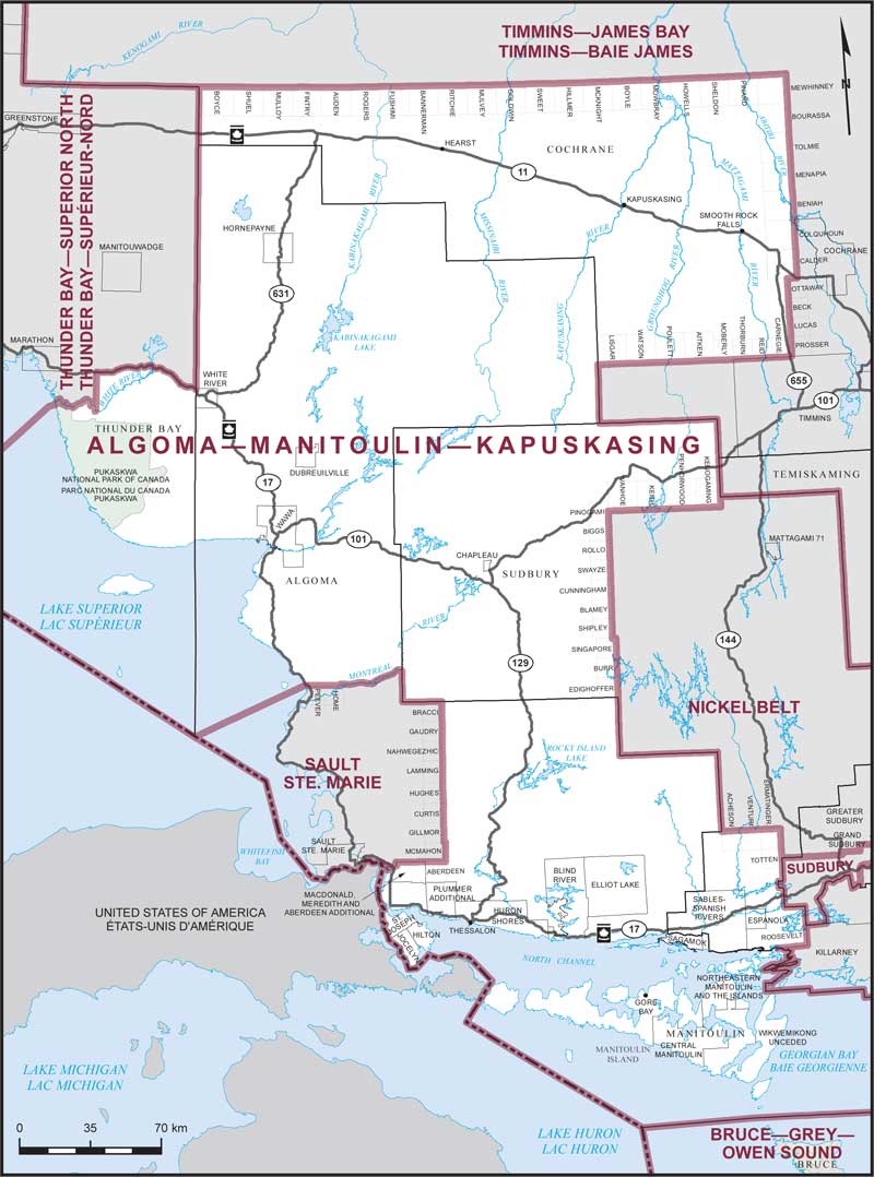
Consisting of:
- (a) the Territorial District of Algoma, excepting that part described as follows: commencing at the intersection of the international boundary between Canada and the United States of America with the southeasterly corner of the Territorial District of Thunder Bay; thence N45°00'E in a straight line to the intersection of the northern shoreline of Lake Superior with the northerly boundary of the geographic Township of Peever; thence easterly along the northerly boundary of the geographic townships of Peever and Home to the Montreal River; thence generally easterly along said river to the easterly limit of the Territorial District of Algoma; thence southerly and easterly along the limit of said territorial district to the easterly boundary of the geographic Township of Bracci; thence southerly along said boundary and the easterly boundary of the geographic townships of Gaudry, Nahwegezhic, Lamming, Hughes, Curtis, Gillmor and McMahon to the northerly boundary of the geographic Township of Aberdeen; thence westerly along said boundary to the northerly limit of the Township of MacDonald, Meredith and Aberdeen Additional; thence generally westerly along said limit to the international boundary between Canada and the United States of America; thence generally westerly and northwesterly along said boundary to the point of commencement;
- (b) the Territorial District of Manitoulin;
- (c) those parts of the Territorial District of Sudbury comprised of:
- (i) that part described as follows: commencing at the northwestern corner of the geographic Township of Acheson; thence easterly along the northerly boundary of the geographic townships of Acheson, Venturi and Ermatinger to the northeastern corner of the geographic Township of Ermatinger; thence southerly along the easterly boundary of the geographic townships of Ermatinger and Totten to the westerly limit of the City of Greater Sudbury; thence generally southerly along said limit to the northeastern corner of the geographic Township of Roosevelt; thence southerly along the easterly boundary of said geographic township to its southerly boundary; thence westerly along the southerly limits of the townships of Roosevelt and Curtin to the southerly limit of said territorial district; thence generally westerly and northerly along the limits of said territorial district to the point of commencement;
- (ii) that part lying westerly and northerly of a line described as follows: commencing at the southeastern corner of the geographic Township of Edighoffer; thence northerly along the easterly boundary of the geographic townships of Edighoffer, Burr, Singapore, Shipley, Blamey, Cunningham, Swayze, Rollo, Biggs and Pinogami to the southerly boundary of the geographic Township of Ivanhoe; thence easterly along said boundary and the southerly boundary of the geographic townships of Keith, Penhorwood and Kenogaming to the southeastern corner of the geographic Township of Kenogaming; thence northerly along the easterly boundary of said geographic township to the northerly limit of said territorial district;
- (d) that part of the Territorial District of Thunder Bay lying southerly of a line described as follows: commencing at the intersection of the easterly limit of said territorial district with the Trans-Canada Highway (Highway No. 17); thence generally westerly along said highway to longitude 86°00'W; thence southerly along said longitude to the White River; thence generally westerly along said river to the northern shoreline of Lake Superior; thence S45°00'W in a straight line to the international boundary between Canada and the United States of America; and
- (e) that part of the Territorial District of Cochrane described as follows: commencing at the intersection of the westerly limit of said territorial district with the northwestern corner of the geographic Township of Boyce; thence easterly along the northerly boundary of the geographic townships of Boyce, Shuel, Mulloy, Fintry, Auden, Rogers, Fushimi, Bannerman, Ritchie, Mulvey, Goldwin, Sweet, Hillmer, McKnight, Boyle, Mowbray, Howells, Sheldon, Pinard and Mewhinney to the northeastern corner of the geographic Township of Mewhinney; thence southerly along the easterly boundary of the geographic townships of Mewhinney, Bourassa, Tolmie, Menapia, Beniah, Colquhoun and Calder to the northerly boundary of the geographic Township of Ottaway; thence westerly along the northerly boundary of said geographic township to its northwestern corner; thence southerly along the westerly boundary of the geographic townships of Ottaway, Beck, Lucas and Prosser to the southwestern corner of the geographic Township of Prosser; thence westerly along the southerly boundary of the geographic townships of Carnegie, Reid, Thorburn, Moberly, Aitken, Poulett, Watson and Lisgar to the southwesterly limit of said territorial district; thence generally northwesterly along said limit to the point of commencement.