
Comment 12 – comments and feedback
Back to all comments and feedback from the public
Chris Erl
Presentation to the Ontario Electoral Boundaries Commission
Outline:
- Who am I?
- Observations about the proposed electoral boundaries
- Alternative suggestion
Who am I?
- Born-and-raised Hamiltonian
- B.A. (Hon.) and M.A. from McMaster
- M.Pl (Planning) from Toronto Metropolitan University (TMU)
- PhD in Political Geography from McGill
- Current Postdoctoral Fellow at TMU
Observations
- The Commission has a challenging task
- The electoral boundaries offer minor changes to Hamilton's existing electoral districts
- The districts, as drawn in 2012, have serious flaws
Observations
- Flamborough-Glanbrook covers too much of the city and combines too many distinct communities
- HWAD similarly combines many disparate communities while leaving out natural pairings
- Hamilton Centre and Hamilton Mountain feature unique east/west and north/south communities (respectively) and no longer serve to create an identifiable community of interest
- Hamilton-Stoney Creek-Lakeshore is a long and diverse electoral district, which may diminish the political power of marginalized residents while, again, leaving out natural pairings
Alternate Suggestion
- Redraw the city's electoral boundaries with an eye to the city's history
- Combine natural community groups together
- Move on from the notion that the Niagara Escarpment creates a strong social barrier
- Unite rural areas and allow room for growth
- Thus, I propose

Alternate Suggestion
- Ancaster-Dundas-Flamborough-Wentworth: 119,889 (+1.03)
- Hamilton-Stoney Creek-Grimsby Lakeshore: 119,886 (+1.03)
- Hamilton South-Binbrook: 118,885 (+1.02)
- Hamilton East: 118,981 (+1.02)
- Hamilton West: 118,114 (+1.01)
Chris Erl – Proposals for the Electoral Boundaries Commission for the Province of Ontario
Submission for the Consideration of the Electoral Boundaries Commission for the Province of Ontario
Members of the Electoral Boundaries Commission for the Province of Ontario:
I am grateful for the opportunity to share my thoughts with the Commission during the 2022 round of Electoral Boundary Readjustments. I approach the Commission's proposals for new electoral district boundaries for the City of Hamilton from a number of unique perspectives.
First, I am a scholar of political geography. I recently defended my doctoral dissertation in the field of political geography at McGill University (my convocation will occur a month from my submission to the Commission). During the course of my studies, I have worked with scholars who focus on electoral boundaries and have written enthusiastically about electoral districts in both academic and popular media settings.
Second, I am a born-and-raised Hamiltonian with a long family history in this city. I have lived across Hamilton and am presently living in the Strathcona neighbourhood, located in Hamilton Centre. I have previously been involved in active politics in Hamilton at all levels and, as such, have been afforded opportunities to experience so much of this city in a unique and rewarding way.
As such, I base my comments on both on my academic understanding of the community and of my own personal experiences in Hamilton. Claims are made by using evidence and data, while personal observations fill in the gaps where sufficient statistical work or research has not yet occurred.
I will begin by reviewing the Commission's initial proposal and providing some basic figures about the electoral district boundaries as proposed. I will then move into my critiques of the boundaries and follow those observations with an alternate proposal that I respectfully submit to the Commission for their consideration.
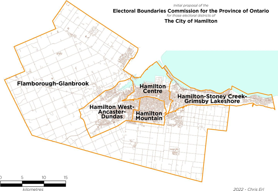
Commission's Initial Proposal
The Commission has proposed an electoral map for Hamilton that features, for the most part, minor changes. They are as such:
- Hamilton West-Ancaster-Dundas: boundaries now include the Carpenter neighbourhood of the south mountain while relinquishing the uninhabited portion of the city made up of Burlington Heights, the Royal Botanical Gardens, and Woodland Cemetery to Hamilton Centre.
- Hamilton Mountain: boundaries now extend south to their pre-2012 redistribution limits, stretching past Rymal Road to the hydro corridor.
- Flamborough-Glanbrook: loses the aforementioned sections to Hamilton West-Ancaster-Dundas and Hamilton Mountain.
- Hamilton Centre: boundaries are extended eastward past Kenilworth Avenue to now include all of the Bartonville, Homeside, and Rosedale neighbourhoods, as well as those sections of the Normanhurst and Glenview West neighbourhoods that are west of Walter Avenue.
- Hamilton East-Stoney Creek: boundaries are pushed on their western front by the aforementioned change and extended on their eastern front to include the Town of Grimsby.

Figure 1: Initial proposal for Hamilton's electoral districts
| Electoral District Name | 2021 Population | 2022 Deviation from Quota | Estimated size in km2 |
|---|---|---|---|
| Flamborough-Glanbrook | 114,701 | -1.62% | 887.66 km2 |
| Hamilton Centre | 123,520 | +5.94% | 61 km2 |
| Hamilton Mountain | 115,634 | -0.82% | 38.24 km2 |
| Hamilton-Stoney Creek-Grimsby Lakeshore | 121,709 | +4.39% | 91.36 km2 |
| Hamilton West- Ancaster-Dundas | 120,551 | +3.40% | 102.81 km2 |
These electoral districts are distinct in many ways. Notably, the combined populations have some observable differences.
| Electoral District Name | Median after-tax household income (2016 data) | Number of Census Dissemination Areas where the median after-tax household income is below the LICO for a family of 4 | Percent of the electoral district who are immigrants (2016 data) | Percent of the electoral district's households that rent (2016 data) |
|---|---|---|---|---|
| Flamborough-Glanbrook | $88,509 | 0 | 18.56% | 9.78% |
| Hamilton Centre | $49,072 | 94 | 22.37% | 54.63% |
| Hamilton Mountain | $65,536 | 25 | 26.54% | 29.32% |
| Hamilton-Stoney Creek-Grimsby Lakeshore | $66,758 | 23 | 27.20% | 29.59% |
| Hamilton West- Ancaster-Dundas | $81,185 | 12 | 26.12% | 24.32% |
Critiques
I want to begin by acknowledging the difficult task faced by the Commission. Working to ensure effective representation based on historical patterns, communities of interest, and geographic constraints makes the re-drawing of electoral boundaries an especially unique challenge. I understand that the current electoral boundaries were drawn in such a way as to fit with other growth-related challenges in the surrounding areas and to provide some level of consistency to the area by building off Hamilton's existing electoral districts. These pre-existing electoral districts have been shaped and formed over time and have been based on the city's growth patterns.
I contend that these electoral districts no longer provide Hamiltonians with adequate representation, are not aligned in such a way as to connect natural communities of interest, and make campaigning prohibitive for a diverse array of candidates.
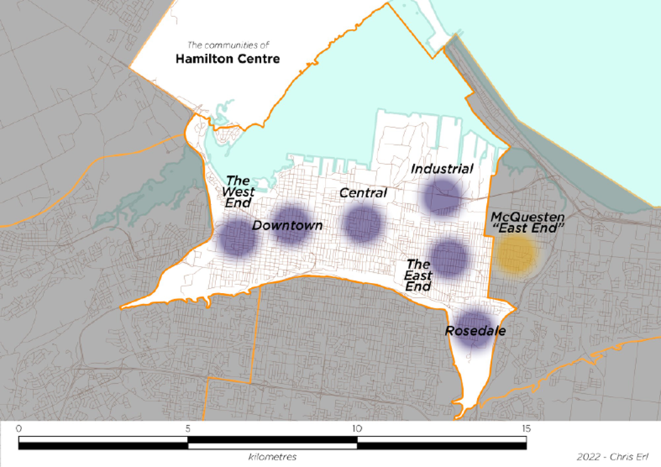
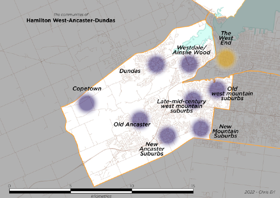
First, I want to provide an overview of the distinct "regions" of Hamilton.
Hamilton is a fascinating community, having grown and shifted in a unique way over the past 176 years. Much of this has been based on the complex geographic challenges the city faces in the form of the Niagara Escarpment, which cuts through the city, and the city's waterways, which are separated by two unique geographic formations: Burlington Heights and the sandbar that makes up the Beach Strip.
Despite this, there are observable "regions" in the city with their own distinct centres, mostly consistent built forms, community composition, and, in some cases, distinct local businesses or cultural scenes that create unique communities of interest.

Figure 2: The "Regions" of Hamilton
When the Commission's new electoral boundaries are overlayed onto the city's "regions", it becomes clear that some communities are isolated from their natural neighbours.
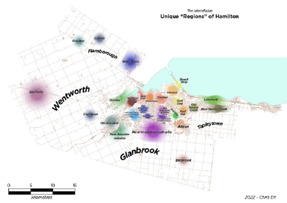
Figure 3: The "Regions" of Hamilton with the Commission's proposed boundaries overlayed
The communities of Flamborough, for example, are separated from Dundas, which is paired with the McMaster University-centred communities of Westdale and Ainslie Wood. These communities are also paired with Ancaster, and the two distinct west mountain suburban communities. This combination, while satisfying the demands to adhere closely to the established electoral quota, clusters some communities together that would be better served if they were paired with other neighbouring communities. The west mountain suburbs, for example, are similar in form to Westdale and Ainslie Wood, which also share characteristics with the city's West End and Downtown.
The grouping on Hamilton Mountain is of notable concern, as it brings the aging suburbs on the northeast mountain into a political community with the late-mid-century suburbs that exist around Limeridge Mall and the new build suburbs, which stretch from Upper Paradise Road in the west to Upper Ottawa Street in the east. Similarly, the isolation of the McQuesten neighbourhood, one of Hamilton's poorest and highest need communities, from their neighbours in Hamilton Centre, and their connection to the expansive new electoral district of Hamilton-Stoney Creek-Grimsby Lakeshore means managing the concerns of highly disadvantaged communities in Hamilton's traditional East End and the concerns of the residents of Grimsby, a community on the western end of Niagara's wine country.
Beyond these concerns, I have comments regarding each electoral district which I will outline here:
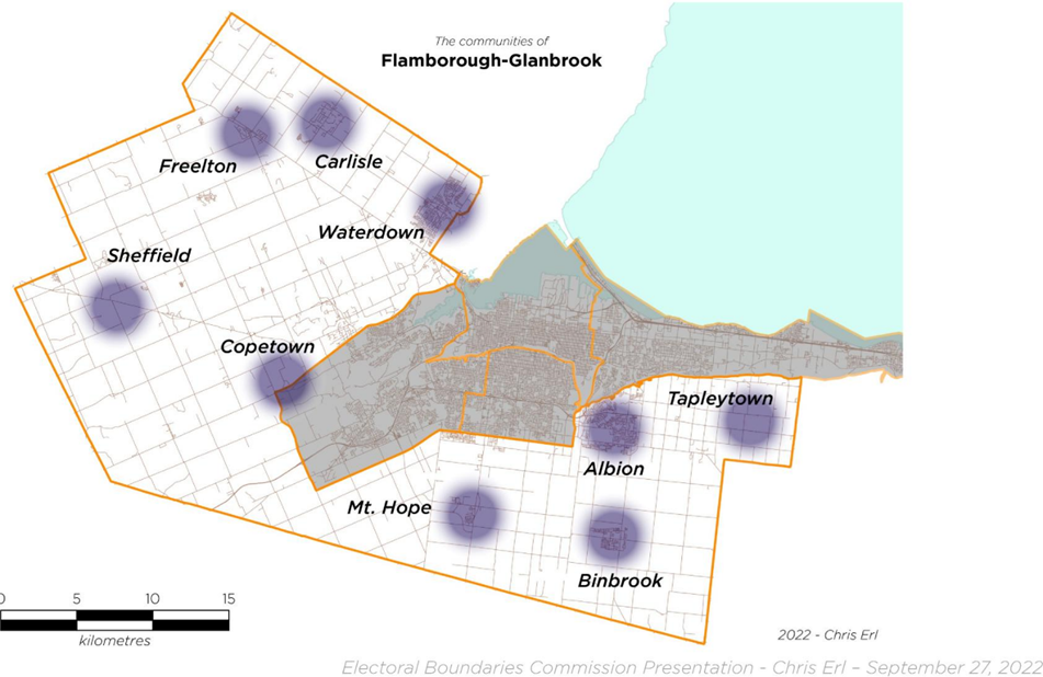
Flamborough-Glanbrook
At 887.66 km2, Flamborough-Glanbrook is a large, mostly rural electoral district that stretches around the urban core of Hamilton. This electoral district also incorporates new growth areas around Waterdown, Binbrook, and the Mount Albion area. While a large electoral district is not a negative per se, the shape of this riding means that very distinct communities are clustered into one electoral district. The distance between the northern most tip of the electoral district and the southernmost is 52 kilometres. If a candidate or MP were in this electoral district were to have a series of meetings, first in Waterdown, then in Sheffield, then in Mount Hope, and ending in Binbrook, to attend these meetings without leaving Flamborough-Glanbrook would take over an hour of navigating back roads. The size and shape of Flamborough-Glanbrook presents the feel that this was an electoral district made up of the "left over" parts of Hamilton, rather than one designed around the unique communities that make up the city.
Hamilton West-Ancaster-Dundas
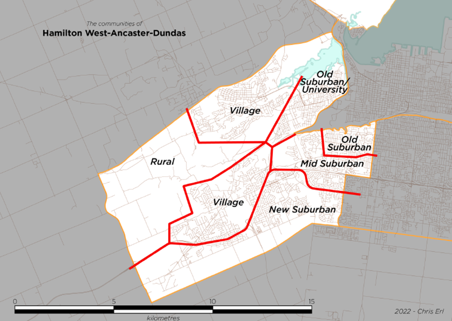
The second-largest of the city's electoral districts, Hamilton West-Ancaster-Dundas (or "HWAD") combines a number of disparate communities into one electoral grouping. HWAD combines Westdale and Ainslie Wood – communities marked by striking poverty and incredible wealth – with the two former suburban communities of Dundas, featuring an older, well-established population, and Ancaster, itself divided into an older established community and a newer suburban section, and the western portions of Hamilton mountain which, itself, features many unique clusters of communities. HWAD is a complicated electoral district, as it seems to include too wide an array of unique communities spread over a large and geographically complex area.
Hamilton Centre
This electoral district combines many of the lower city communities into one electoral grouping. From the Chedoke Creek valley in the west, now nearly to the Red Hill Valley in the east, this is a large, diverse, and changing electoral district. Hamilton Centre clusters communities with high rates of poverty, packing lower income Census Dissemination Areas (DA) into one electoral district spread over a large area.
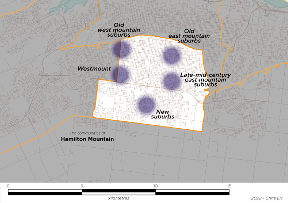
Hamilton Mountain
The electoral district of Hamilton Mountain is, in many ways, the companion to Hamilton Centre. While Hamilton Centre stretches south from the industrial districts along Hamilton Harbour to the Escarpment, Hamilton Mountain stretches south from the Escarpment to the new suburban communities clustered around Rymal Road. This is an electoral district featuring houses that are over 100 years old along the mountain brow and homes that have just been constructed, though it lacks a defined "core" that other electoral districts have in the form of city centres and commercial areas. While Concession Street is a commercial centre, the core of Hamilton Mountain is more likely Limeridge Mall. Hamilton Mountain's older suburbs are aging at a rapid rate and do not share similar concerns to those held by residents in the newer suburban developments further to the south of the electoral district.
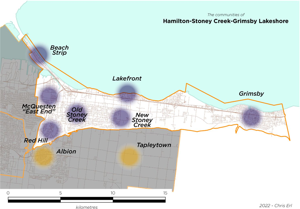
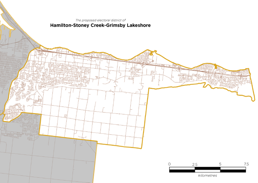
Hamilton-Stoney Creek-Grimsby Lakeshore
This reshaped version of Hamilton East-Stoney Creek is a long and narrow electoral district, encompassing some of Hamilton's poorest communities (the McQuesten Neighbourhood) and some strikingly wealthy communities in Stoney Creek and along the lakeshore of Lake Ontario. This electoral district seeks to manage the city's changing population and ensure a balanced population over the next decade, though, in doing so, diminishes the political power of some of Hamilton's most disadvantaged residents. Similarly, by using the Niagara Escarpment as a border, it isolates residents who live "on the mountain" but may see themselves as more connected to the Stoney Creek community.
Alternate Proposal
Based on the critiques I have of the electoral districts as established for Hamilton, I propose a series of different electoral districts that draw on the unique geography, settlement patterns, and identifiable communities that exist in Hamilton.
These electoral districts are:
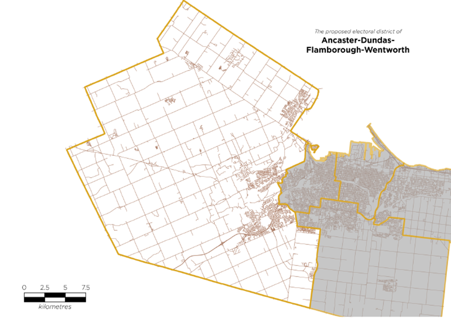
- Ancaster-Dundas-Flamborough-Wentworth
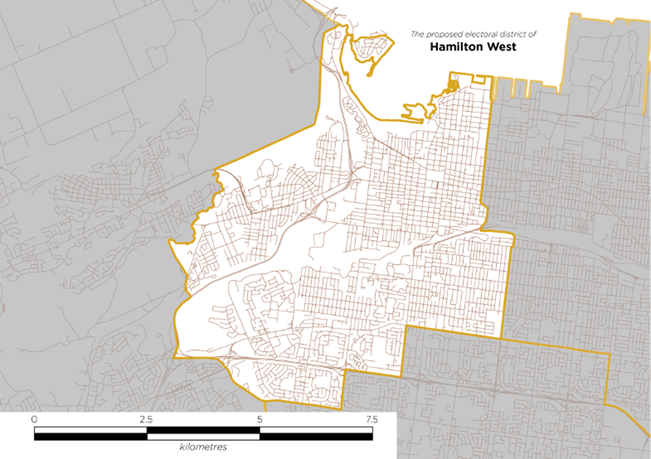
- Hamilton West
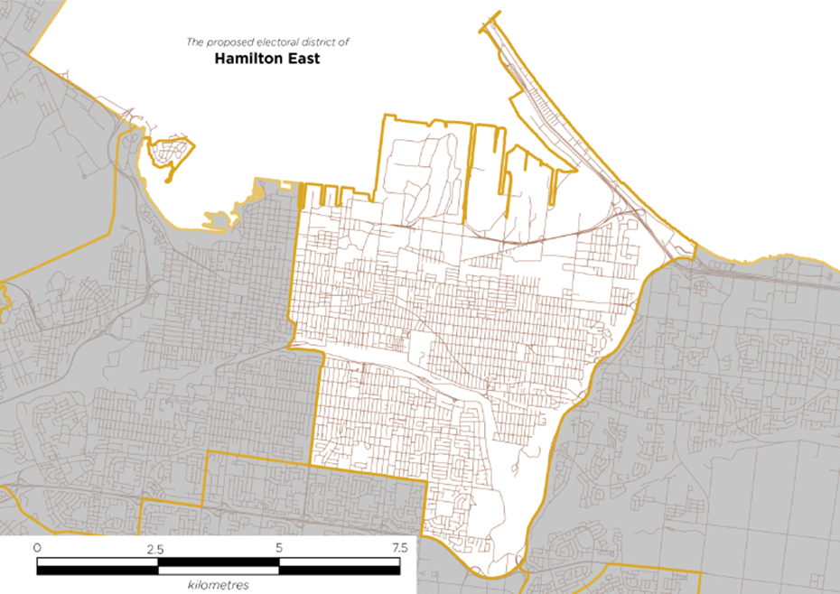
- Hamilton East
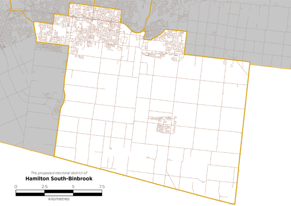
- Hamilton South-Binbrook
- Hamilton-Stoney Creek-Grimsby Lakeshore
| Electoral District Name | 2021 Population (est.) | 2022 Deviation from Quota | Estimated size in km2 |
|---|---|---|---|
| Ancaster-Dundas- Flamborough-Wentworth | 119,889 | +1.03% | 722.73 km2 |
| Hamilton West | 118,114 | +1.01% | 38.75 km2 |
| Hamilton East | 118,981 | +1.02% | 48.7 km2 |
| Hamilton-Stoney Creek-Grimsby Lakeshore | 119,886 | +1.03% | 130.79 km2 |
| Hamilton South- Binbrook | 118,885 | +1.02% | 210.36 km2 |
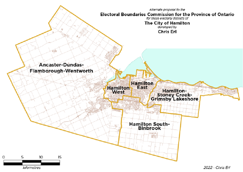
Figure 4: Chris Erl's alternate proposal for Hamilton's electoral districts
These new electoral districts more closely match each other in population, do not feature extreme deviations from the electoral quota, and have historical precedent. This important historical precedent will ensure voters are within electoral boundaries with which they are familiar, and these boundaries build on previously-constituted electoral districts that served the City of Hamilton for, in some cases, over a century.
Hamilton West was represented in the House of Commons from 1904 to 2004 and as recently as 2007 in the Ontario legislature. This electoral district has "hopped" the mountain many times in its past, notably being expanded to include new settlements on the mountain as early as 1935. This tradition of the "west end" of Hamilton being united with similar communities on the western portion of Hamilton mountain was carried through to Hamilton Centre, which included mountain neighbourhoods from its creation in 2003 to the 2012 redistribution.
Hamilton East similarly existed from 1904 to 2003 and, like Hamilton West, was represented in the Ontario legislature until 2007. While Hamilton East never included portions of the mountain, it did include much of the area currently proposed, providing much-needed representation to working class Hamiltonians. The lower city portion of the proposed Hamilton East boundaries follow the boundaries of Hamilton East as they existed when that electoral district was dissolved into Hamilton Centre in 2003 (2007 for the Ontario legislature).
Ancaster-Dundas-Flamborough-Wentworth reunites many of the communities previously represented in Ancaster-Dundas-Flamborough-Westdale from 2004 to 2015, and from Ancaster-Dundas-Flamborough-Aldershot from 2000 to 2004.
Hamilton South was an electoral district covering the southern portions of Hamilton mountain and surrounding rural areas from 1953 to 1968, when it was dissolved mostly into Hamilton Mountain.
Finally, the modified boundaries of Hamilton-Stoney Creek-Grimsby Lakeshore include much of the territory of the former electoral district of Stoney Creek which, upon its dissolution, encompassed the former community of Stoney Creek, the Town of Grimsby, and the portions of upper Stoney Creek around the Albion area and the historic community of Tapplytown.
The new electoral districts provide a closer, more fair electoral division to Hamilton, including roughly similar numbers of residents (based on aggregated estimates from DA-level data from the 2021 Canadian Census). While their sizes have not changed dramatically, the new electoral districts try to more closely adhere to natural breaks and geographic formations in the city.
The proposed electoral district boundaries attempt to ensure both communities of interest are clustered in such a way as to create a natural political community and to provide special consideration for more marginalized members of our community who may see their political power diminished with certain shifts to electoral boundaries. I have included a number of maps in the Appendix that overlay my proposed electoral district boundaries on DA-level data for income, migrant communities, and homeownership/renter status.
| Electoral District Name | Median after-tax household income (2016 data) | Number of Census Dissemination Areas where the median after-tax household income is below the LICO for a family of 4 | Percent of the electoral district who are immigrants (2016 data) | Percent of the electoral district's households that rent (2016 data) |
|---|---|---|---|---|
| Ancaster-Dundas-Flamborough- Wentworth | $91,175 | 3 | 19.01% | 12.39% |
| Hamilton West | $59,006 | 55 | 27.80% | 51.65% |
| Hamilton East | $50,991 | 77 | 19.02% | 39.96% |
| Hamilton-Stoney Creek-Grimsby Lakeshore | $70,624 | 19 | 28.13% | 27.48% |
| Hamilton South- Binbrook | $75,106 | 11 | 27.85% | 18.96% |
Each of the proposed electoral districts will be defined thus:
Ancaster-Dundas-Flamborough-Wentworth: Those areas of the City of Hamilton that were part of the formerly independent communities of Flamborough, Dundas, Ancaster, and Wentworth, and those parts of the former community of Glanbrook lying west of Upper James Street/Highway 6 and south of the hydro right-of-way
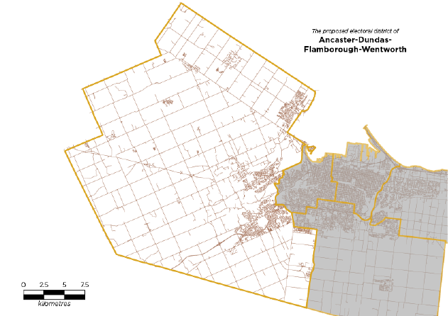
Figure 5: Proposed electoral district of Ancaster-Dundas-Flamborough-Wentworth
Hamilton West: those areas beginning at the city's border with the City of Burlington, following the border westerly to the former border between the City of Hamilton and the Town of Dundas, then south from said border along the boundaries of Hamilton's Ward 1 to where said ward meets the Highway 403, then south along the Highway 403 to the point where said highway meets the Lincoln Alexander Expressway, then east along said parkway, following the centreline of the parkway's southern exit ramp to the intersection of said ramp, Golf Links Road, and Stone Church Road West, then following the centreline of Stone Church Road West to its intersection with Garth Street, then north along Garth Street to its intersection with the Lincoln Alexander Parkway, then east along the Lincoln Alexander Expressway to West 5th Street, then north along West 5th Street to its intersection with Mohawk Road West, then east along Mohawk Road West to its intersection with Upper Wentworth Street, then north along Upper Wentworth to the Sherman Access road, then west along the Sherman Access road to the Clairmont Access road, then north along the Clairmont Access road until said road becomes Wellington Street, then north along Wellington Street to the shoreline of Hamilton Harbour, then along the shoreline of Hamilton Harbour to the point of origin.
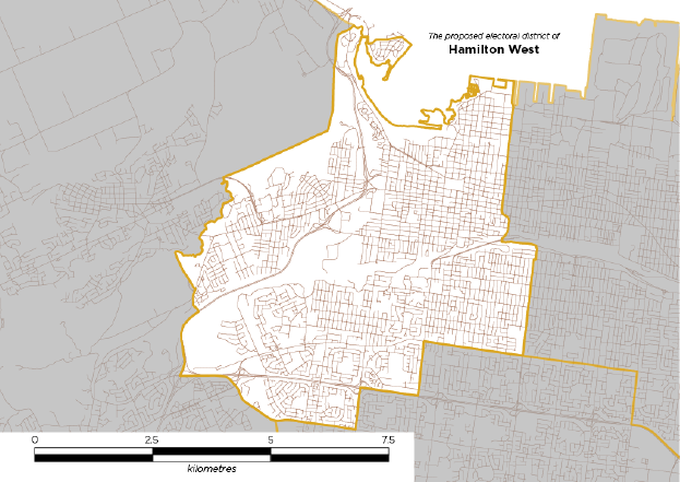
Figure 6: Proposed electoral district of Hamilton West
Hamilton South-Binbrook: Those parts of the City of Hamilton from the city's southern border, westerly to Upper James Street/Highway 6 to its intersection with the hydro right-of-way, then west along the right-of-way to Glancaster Road, north on Glancaster Road to its intersection with Rymal Road West, then north along the former boundary between the City of Hamilton and Town of Ancaster to Stone Church Road West, then following the centreline of Stone Church Road West to its intersection with Garth Street, then north along Garth Street to its intersection with the Lincoln Alexander Parkway, then east along the Lincoln Alexander Expressway to West 5th Street, then north along West 5th Street to its intersection with Mohawk Road West and East until its intersection with Upper Ottawa Street, then south along Upper Ottawa Street to its intersection with the Lincoln Alexander Expressway, then east along the Lincoln Alexander Expressway to the ramps connecting said highway to the Upper Red Hill Valley Expressway, south along said ramps and the Upper Red Hill Valley Expressway to Highland Road West, then east along said road until its intersection with Felker's Creek, then following the creek north and east until the creek's intersection with Mud Street West, then east along Mud Street West to its intersection with the Upper Centennial Parkway, then south along the Upper Centennial Parkway to its intersection with Highway 20, then east along Highway 20 to its intersection with 5th Road East, then in a straight line until it meets the city boundary.
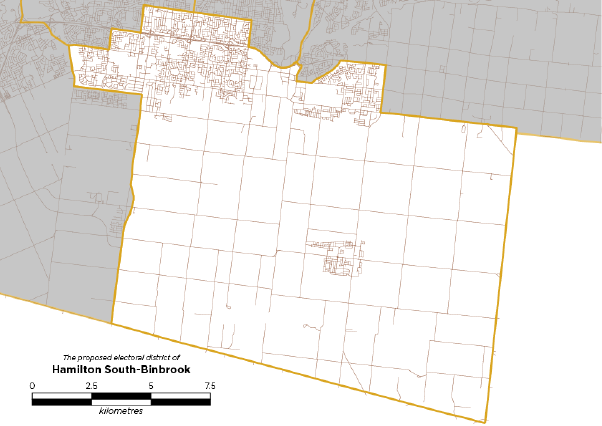
Figure 7: Proposed electoral district of Hamilton South-Binbrook
Hamilton East: those areas of the City of Hamilton from the intersection of the Red Hill Valley Expressway and the Queen Elizabeth Way, south along the centreline of the Red Hill Valley Expressway, following the highway as it becomes the Lincoln Alexander Expressway, then west along the Lincoln Alexander Expressway to its intersection with Upper Ottawa Street, then north along Upper Ottawa Street to its intersection with Mohawk Road East, then west along Mohawk Roads East and West its intersection with Upper Wentworth Street, then north along Upper Wentworth to the Sherman Access road, then west along the Sherman Access road to the Clairmont Access road, then north along the Clairmont Access road until said road becomes Wellington Street, then north along Wellington Street to the shoreline of Hamilton Harbour, then east and north along the shoreline of Hamilton Harbour to the canal that forms part of the border of the City of Hamilton and City of Burlington, then south and east along the shore of Lake Ontario to a point parallel to the point of origin, then south to said point.
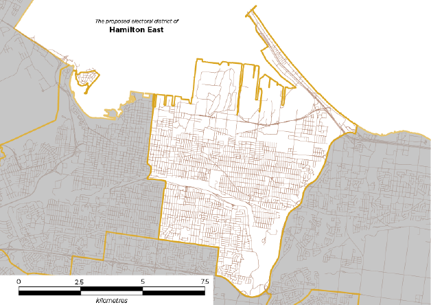
Figure 8: Proposed electoral district of Hamilton East
Hamilton-Stoney Creek-Grimsby Lakeshore: those areas of the City of Hamilton from the intersection of the Red Hill Valley Expressway and the Queen Elizabeth Way, south along the centreline of the Red Hill Valley Expressway to the ramps connecting said highway to the Upper Red Hill Valley Expressway, south along said ramps and the Upper Red Hill Valley Expressway to Highland Road West, then east along said road until its intersection with Felker's Creek, then following the creek north and east until the creek's intersection with Mud Street West, then east along Mud Street West to its intersection with the Upper Centennial Parkway, then south along the Upper Centennial Parkway to its intersection with Highway 20, then east along Highway 20 to its intersection with 5th Road East, then in a straight line until it meets the city boundary, following the city's boundary to the Niagara Escarpment, then east along the Escarpment, into the Town of Grimsby, to said town's eastern border, then north along said border to the shoreline of Lake Ontario, then west along said shoreline to a point parallel to the point of origin, then south to said point.
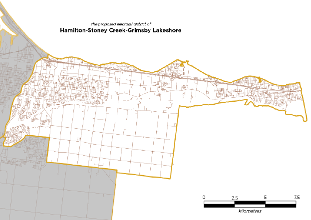
Figure 9: Proposed electoral district of Hamilton-Stoney Creek-Grimsby Lakeshore
Concluding notes
The task before the Electoral Boundaries Commission for the Province of Ontario is a challenging one, as Ontario is a province of uneven settlement patterns, complex geography, and varied communities of interest. The City of Hamilton poses a particular challenge to the Commission due to the area's population and growth.
I contend that, by reworking Hamilton's electoral districts based on historical patterns and with a closer eye to the natural communities of interest that exist in the city, a more fair and reasonable electoral map can be drawn. Recognizing that the Niagara Escarpment is not nearly as daunting a barrier as it may seem, that communities both down and up the mountain may share concerns, that former suburban communities may share characteristics that make them natural partners in an electoral grouping, and that the city's rural and urban areas deserve more clearly defined boundaries can help to fix an awkward electoral map.
In particular, recognizing that a "Hamilton Centre" and "Hamilton Mountain" may not be necessary to provide effective representation is key. West Hamilton constitutes a community of interest that does not need to be split between three electoral districts. East Hamiltonians both above and below the Niagara Escarpment share concerns, perspectives, and community. The new suburbs of Hamilton's south mountain differ greatly from their north mountain counterparts. Rural residents in Ancaster share common concerns with rural residents in Freelton while their suburban neighbours in Waterdown may have different concerns around local issues than those living 25 kilometres away in Binbrook.
The electoral map I have proposed is not perfect, but it does go a long way to correcting some of the imbalances created by the 2012 redistribution. Reuniting natural communities of interest and reshaping the city's more cumbersome electoral districts will help to provide a fair, reasonable, and consistent electoral scene into which Hamiltonians from all walks of life can contribute.
Thank you,
Chris Erl
(he/him)
B.A. (Hon), M.A., M.Pl., PhD.
Appendix
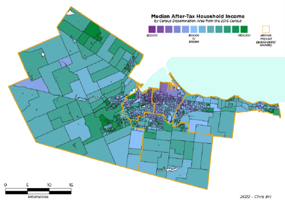
Figure 10: New boundaries overlayed on Census Dissemination Areas depicting Median After-Tax Household Income
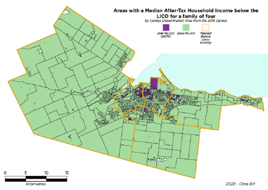
Figure 11: New boundaries overlayed on Census Dissemination Areas depicting those households with a Median After-Tax
Household Income lower than the 2020 LICO for a 4-person household
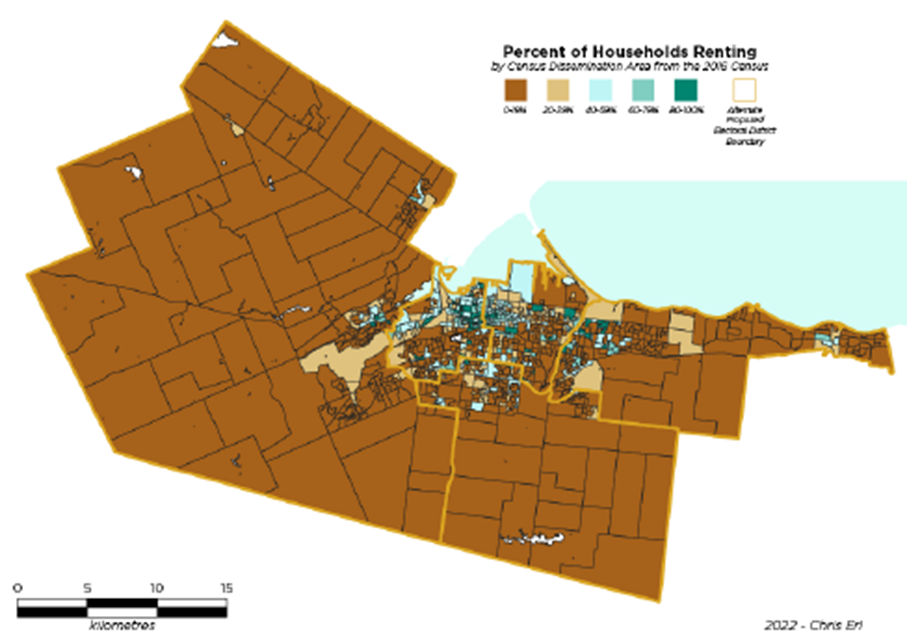
Figure 12: New boundaries overlayed on Census Dissemination Areas depicting percent of households renting
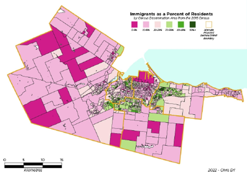
Figure 13: New boundaries overlayed on Census Dissemination Areas depicting immigrants as a percent of residents