
Comment 13 – comments and feedback
Back to all comments and feedback from the public
Anna Roberts
Dear Ms. Puddy,
RE: Redistribution proposal for the Riding of King—Vaughan
I am writing to address the Ontario Federal Electoral Boundaries Commission's proposal to redraw the boundaries of the King—Vaughan electoral riding.
I would like to propose 2 different scenarios for the Commission to consider rather than the current proposal. I believe that my recommendations may offer a smoother transition for King—Vaughan with minimal negative impact.
Using significant landmarks like highways, rivers, lakes, etc. to divide ridings is one of the Commission's objectives when establishing new ridings. The Commission's current proposal uses minor streets rather than major landmarks and we feel this will make it much more difficult for our population to understand which riding they reside in. When a population doesn't easily understand their riding boundaries it causes confusion when reaching out to Member of Parliament offices and can also negatively effect voter turnout. In our riding alone in the 2021 federal election we had a voter turnout of 49%, which was down from the previous 2019 election of 64%. We believe that the current redistribution proposal will only lower this turnout in our riding.
I am aware that King—Vaughan's population is growing significantly, therefore I would like to propose an alternative plan that will be less disruptive, to the community than the Commission's proposal.
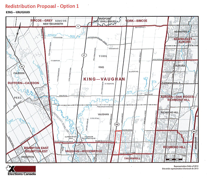
In this proposal as outlined on the map above in red, the major roads of Rutherford Road, Jane Street, Teston Road, and Highway 400 would be used as a new boundary and added to the riding of Vaughan—Woodbridge. According to my office's calculations this could deduct around 5,000–8,000 residents from the total population of King—Vaughan.
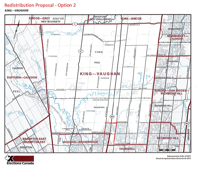
If the Commission determines that more residents need to be removed from the population of King—Vaughan, this second proposal as outlined above in red would remove around 8,000–10,000 residents from the total population of King—Vaughan to also be added into the riding of Vaughan—Woodbridge. This proposal uses the major roads of Weston Road, Teston Road, Jane Street and Rutherford Road as riding boundaries.
Both proposals are much more advantageous than the current redistribution proposal because of the use of major roads. Using major roads will make this redistribution much easier for residents to grasp than using the minor roads of Nashville Road, Peter Rupert Avenue and 18th Sideroad.
This proposal also keeps the historical communities of King Township, Kleinburg and Thornhill intact (described below). This proposal allows you to retain all the current riding names that comprise Vaughan. King—Vaughan, and Vaughan—Woodbridge can all remain to be identified by their current names.
According to Elections Canada Data from the 2021 Federal Election both ridings of King—Vaughan and Thornhill have much greater populations than Vaughan—Woodbridge, therefore Vaughan—Woodbridge is the riding that the Commission should be focusing on to add residents to.
| Electoral Riding | King—Vaughan | Thornhill | Vaugh—Woodbridge |
| Population | 131,995 | 112,719 | 105,228 |
|---|---|---|---|
| # of Electors On the List | 102,820 | 85,739 | 80,832 |
Our recommendations would preserve the three Vaughan ridings within the commission's target population range and ensure that a district's population is not more than 25% above or below the average for the district.
How the Commission's Current Proposal Negatively Impacts the current Communities in King—Vaughan
Current Proposal's Negative Impacts on the Historical Township of King
Currently, the riding of King—Vaughan includes the township of King, commonly known as the community of small communities. King Township includes the historical communities of King City, Schomburg, Kettleby and Nobleton. By creating the new riding of New Tecumseth—Bradford and moving King—Vaughan's boundary south to Sideroad 18 the Commission risks separating these small historical communities and isolating them from their Township.
Quoting the Commission directly:
"However, in addition to population equality, commissions must consider other social and geographic factors. They may choose to create electoral districts whose populations vary from the average, if they consider it necessary or desirable in order to: Respect communities of interest or identity (for example, communities based around language or shared culture and history), Respect historical patterns of previous electoral boundaries."
The current proposal does not respect the shared culture and history of King Township by splitting this community into 2 separate ridings and therefore I ask you to reconsider this.
The Township of King has major historical roots in Canadian society and therefore deserves the respect to remain as one community in a federal riding. Indigenous peoples have been living in and travelling through the region that is now known as the Township of King for generations. The Toronto Carrying Place Trail, a significant route along the Humber and Holland Rivers between Lake Ontario and Lake Simcoe, was frequented by indigenous people. The township was first surveyed in 1800 under John Graves Simcoe, the first Lieutenant–Governor of Upper Canada (now southern Ontario). Named King Township by Simcoe in honour of Major John King, English Under–Secretary of State, the area remained sparsely settled until the building of roads in the 1820s improved travel.
The communities of Schomberg and Llyodtown who have historical footprints in King Township dating back to the early 1800's are two of the small communities at risk of being isolated from the Township of King due to the Commission's current proposal.
Schomberg grew around the land and activities of the Brown brothers, Pennsylvania Quakers, who arrived in the 1830s. Before long there was a mill, a bank, general stores, a tannery, a blacksmith shop, a wagon shop, two shoe shops serving the 1850 popillation of 100. The community was first named Brownsville but the coming of the post office in 1862 saw the name change to Schomberg in honour of the Duke of Schomberg. Prosperity continued with the 1902 arrival of the Aurora & Schomberg Railway terminus. First held in 1852, the annual agricultural fair takes place at the end of May.
Lloydtown named after Jesse Lloyd, a Pennsylvania Quaker, and his 14–year–old wife Phoebe Crossley, settled the area and started the first grist mill in 1826. Growth quickly followed and within several years the area included two churches, two cooperages, three hotels, three blacksmith shops, a tannery, several stores and more. Joining William Lyon Mackenzie, Jesse Lloyd organised and led others in the failed 1837 Upper Canada Rebellion in nearby York (Toronto). The Lloyd family cemetery and a statue dedicated to the rebels stand as a reminder of its past.
Another community within the Township at risk of isolation due to the Commission's current proposal is Kettleby. Kettleby was once one of the busiest locations in the township. In 1842 when Captain Septimus Tyrwhitt bought 46 acres the area's growth really started. Tyrwhitt built a huge flour mill, a woollen mill, an oatmeal mill, a cooperage and a distillery. An officer in the British Militia Garrison in York during the 1837 Rebellion, Tyrwhitt named the community after his aristocratic family's ancestral home of Kettleby in Lincolnshire, England. Kettleby proudly boasted several hotels, shoemakers, blacksmith a dressmaker, a milliner, a weaver and a tailor. There was also a general store, wagon maker, farm implement factory and a Temperance Hall with the largest membership in Ontario. Nestled in a valley, Kettleby's many 19th century homes line the winding, narrow road that crosses a single lane bridge over the Kettleby Creek.
As previously stated, the township of King has major historical roots in Canadian history and therefore all its small communities deserve to be included into one Federal riding.
Current Proposal's Negative Impacts on the City of Vaughan
The current Commission's proposal will also divide the historic community of Kleinburg, by moving our riding boarder from Major Mackenzie Drive to Nashville Road. The community of Kleinburg is comprised of a narrow section of hilly landscape situated between two branches of the Humber River. The historic village is bounded by I Iighway 27 on the west and Stegman's Mill Road on the east. Therefore, the current proposal puts part of Kleinburg in the riding of Vaughan—Woodbridge.
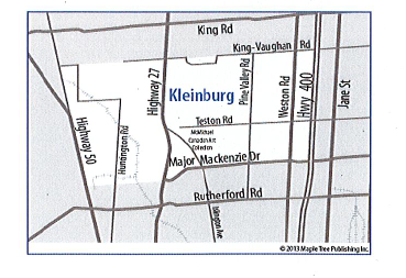
Kleinburg developed around numerous mills like many other riverside villages. In 1848, John Nicholas Kline bought 33 hectares (83 acres) of Lot 24 in Concession 8 west of Islington Avenue. On this land, Kline built a sawmill and gristmill. This land was then divided into eight smaller individual lots, encouraging the establishment of the village. The Kline Mills not only served the local farming community but also became the backbone of a growing commercial centre. It is assumed Kleinburg was named after Kline, however, its present spelling was derived from a combination of two German words: Klein, meaning "little or small" and berg, meaning "mountain." The name "small mountain" perfectly describes the topography and environmental setting of Kleinburg.
Therefore, the commission diving this community into 2 separate ridings in its current proposal does not respect the community of Kleinburg's historical identity that has been intact since 1848.
Current Proposal's Negative Impacts on Thornhill and Peter Rupert Avenue Subdivision
The commission's current proposal also plans to change the southeastern boarder of King—Vaughan from Rutherford Road and Bathurst to Peter Rupert Road and Major Mackenzie. This will negatively impact constituents in both King—Vaughan and Thornhill. The riding of Thornhill has remained unchanged for nearly 25 years and altering this while also changing its name to Vaughan—Thornhill could have significant impact and does not respect historical patterns of previous electoral boundaries.
Using Peter Rupert Avenue as a boundary will certainly cause confusion for the residents in that subdivision. The allocated elementary school for residents living off of Peter Rupert Avenue is St. Cecilia Catholic Elementary School, 300 Peter Rupert Ave, Maple ON L6A 4P3, which lies west of Peter Rupert Ave, and would remain in the riding of King—Vaughan according to the commission's proposal. Therefore, if the boarder of King—Vaughan is moved to Peter Rupert Avenue residents that live east of Peter Rupert Ave will be living in one riding while attending school in a separate federal riding, even though they are considered one housing subdivision. Come election time when schools are commonly used as polling locations residents in half of the Peter Rupert subdivision will be able to vote at their local school, while the other half of residents will be forced to vote elsewhere. St. Cecilia was just used as a polling location for the 2022 Ontario provincial election where all residents in the Peter Rupert subdivision area were able to simply walk down the street to their local school and vote. Altering this for the next election could therefore have a significant negative impact to voter turnout whereby residents will be confused why they can no longer use their local school to cast their ballot. Moving the eastern boundary from the major road of Bathurst Street to the minor road of Perter Rupert Ave will certainly cause confusion among residents and can negatively impact voter turnout in both King—Vaughan and Thornhill.
Thank you for your consideration and I look forward to hearing back from you regarding my thoughts.
Anna Roberts, Member of Parliament
King—Vaughan