Comment 168 – comments and feedback
Back to all comments and feedback from the public
Ryan McNally
See attached.
I am sending this via email, because the interactive mapping tool has repeatedly given me a "no token" error this evening. Twice I worked with the map to modify the boundary for Thunder Bay - Superior North, only to have this error block my submission on the last screen.
I am concerned about the proposed southern boundary of the riding, within the Municipality of Oliver Paipoonge and between Oliver Paipoonge and Conmee Township. The Commissions proposed boundary would divide the hamlet of Kakabeka Falls, placing 20 residences in one riding and 50 in the other. It would similarly divide residents of Conmee Township. Further, the boundary does not divide the area in line with historic local understanding.
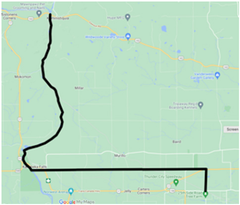
If the municipality of Oliver Paipoonge is to be divided between two ridings, it should be divided based on the pre-1998 municipal boundaries, so the geographic township of Oliver is in Thunder Bay - Superior North and the geographic township of Paipoonge is in the other riding. The boundary would be adjusted as follows:
- at the point where Arthur Street West crosses the boundary of the City of Thunder Bay and the Municipality of Oliver Paipoonge, the riding boundary should proceed north along the boundary of the geographic township of Paipoonge to the point where the township boundary turns west,
- Then the riding boundary should proceed west, following a projection to Pole Line Road,
- then along Pole Line Road to where it meets Hwy. 11/17,
- Then projected west from Pole Line Road, along the boundary between the geographic township of Oliver and the geographic township of Paipoonge, to the point where the line meets the Kaministiquia River,
- The along the centre of the river, on the boundary between Oliver Paipoonge and Conmee, to the point where the line meets Hwy. 102.
A sketch, made using Google Maps, is included below.
This change to the Commission's proposal better respects natural geographic features, communities of interest, and historic community boundaries without unnecessarily or awkwardly dividing communities and municipalities. I expect the change will not result in a significant change in the population of each riding, as there will be an exchange between the two.
Sincerely,
Ryan McNally Murillo, Ontario

