Comment 104 – comments and feedback
Back to all comments and feedback from the public
Josh Chadwick
When our team first met to review the proposals put forward by the commission for the London area, we agreed that the proposed boundaries for the new London Centre riding are not unreasonable. There are some issues, however, that cause reason for concern.
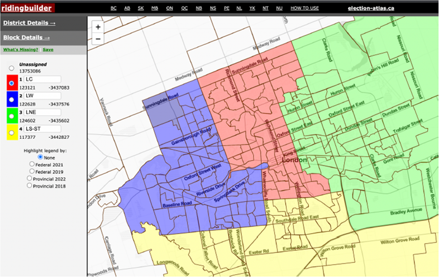
There are three geographic areas of the London Centre proposal which we would like to focus on, beginning in the southwest corner of the new riding.
Through conversations with our counterparts in London West, we have come to understand that the area in question bound by the Thames River in the north, Wharncliffe Road in the east, Commissioners Road to the south and Wonderland Road to the west, form a community of interest that has a logical fit with the proposed London West area. As such, we feel that the boundary for this area should be altered to maintain that connection.
Moving this area into the new London West would necessitate certain other changes in that riding which have been well described in the submission offered by representatives of the London West Liberal Riding Association and those of MP Kayabaga. Yet, this change on its own would create a population imbalance in the proposed London Centre — one that can be addressed along the eastern boundary.
The commission's proposal includes an offshoot along Hamilton Road in an area bordered by the CN tracks to the north, the south branch of the river to the south, and Highbury Avenue, in the east. We suggest shifting that area south using the river as the northern natural boundary, Commissioners Road to the south and either Pond Mills Road or Highbury Ave. to the east. It is our view that this division would cause less confusion for local residents as to who their parliamentary representative is. This would be achieved by standardizing the representative to the Member of Parliament for London Northeast regardless of what portion of Egerton Street or Highbury Avenue is considered in this area. This change also continues to respect a natural boundary and keeps community together.
Finally, we turn our focus to the northeast. You have been offered other proposals that impact this portion of the city. Frankly, it would appear the primary motive behind some of these other suggestions is to either reach a population target regardless of impact on community, or to achieve what could be viewed as a partisan goal. In any event, the suggestions sever community connections in this region.
The commission's proposal seeks to use Adelaide as a boundary for the east portion of the riding, except for the previously discussed offshoot. This does make sense, at least for the most part, as it creates a clean delineation between London Centre and London Northeast that is consistent with established community divisions.
For example, the Woodfield area is a clearly separate community from the Old East Village and the division between the two is Adelaide Street, or Old North and Bishop Helmuth communities on the west side of Adelaide versus the Carling community on the east. In the northeast portion of London Centre, that line of separation is not as clear. School boundaries, community bonds, and infrastructure utilization unify the east and west side of Adelaide north of the river. The city of London has recognized this commonality through their electoral ward boundaries in this area, as both east and west of Adelaide (north of the river), is entirely within one ward represented by one councillor.
Additionally, some have proposed using Sunningdale Road as the north south boundary in this area. This too would directly split a growing community by adding the subdivision north of Sunningdale but south of the city limits to the surrounding rural riding. The blending of urban and rural areas is necessary in many locations. In areas where this is proposed elsewhere in the province, there is a clear attempt to keep neighbourhoods unified. Other proposals for London's northeast fail to adhere to this for what appear to be purely partisan purposes.
Instead, we see a natural fit for the area bounded by the city limits in the north, Highbury Ave. in the east and the river to the south to be included with the new London Centre. This is primarily based on the principle of keeping this community unified and making use of the natural boundaries that exist.
Moreover, it is our view that these minor changes would have a positive impact in maintaining the unity of these communities while at the same time maintaining the basic proposal of the commission, thereby not causing too much of a domino effect across the region. And while we understand that partisan considerations are not within the purview of the commission, our proposals have sought to balance the traditional political tendencies in each of the changed areas so as not to overtly favour any one group. Furthermore — and crucially — under our London proposal, each riding would have a population number that is very much in line with the commission's target.
With that, we thank you for your time in consideration of our proposal.
Respectfully submitted by:
Josh Chadwick, Chair
London North Centre
Federal Liberal Association