
Nickel Belt – Existing boundaries
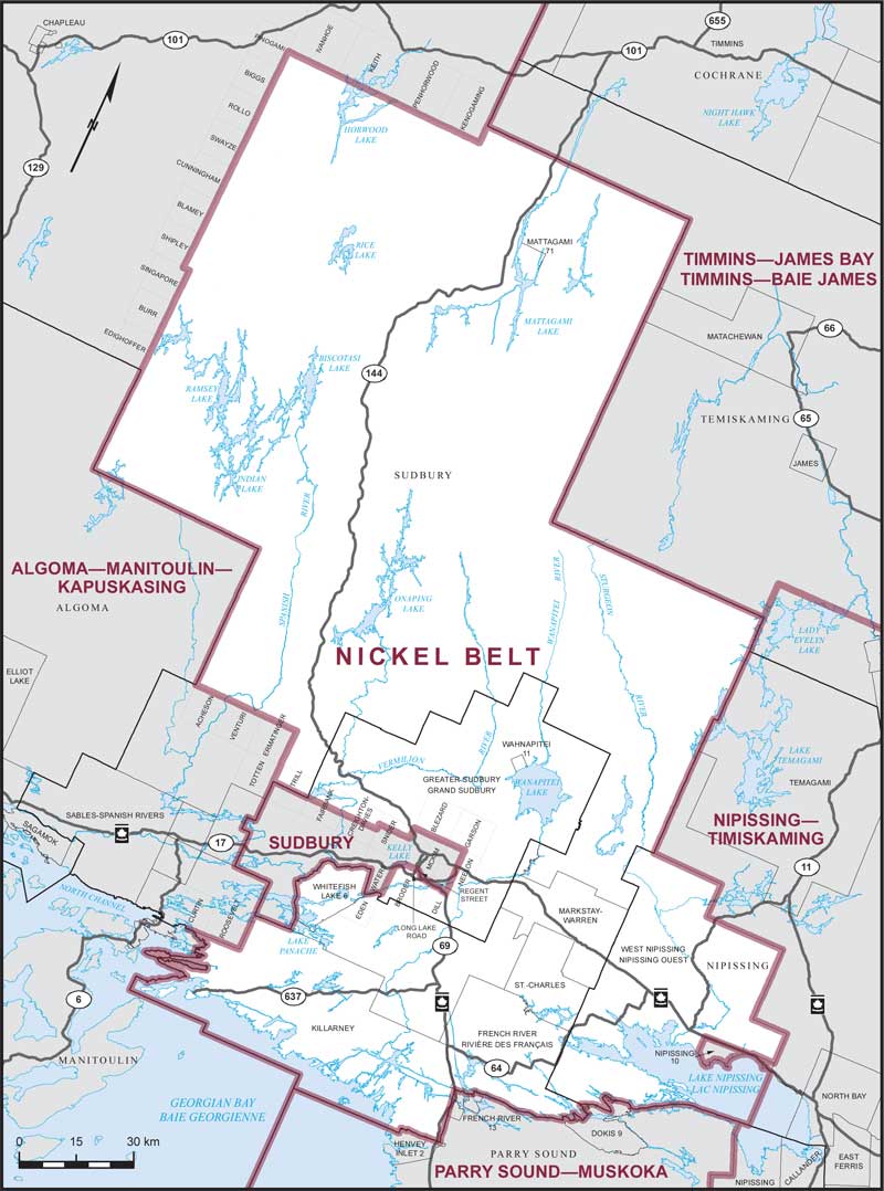
Consisting of:
- (a) that part of the Territorial District of Nipissing comprised of the Municipality of West Nipissing, excepting Nipissing Indian Reserve No. 10;
- (b) the City of Greater Sudbury, excepting that part described as follows: commencing at the intersection of Highway No. 17 with Highway No. 69; thence generally westerly and northwesterly along Highway No. 69 and Highway No. 46 (Regent Street) to Long Lake Road (Regional Road No. 80); thence southerly along said road to the southerly boundary of the geographic Township of McKim; thence westerly along said boundary to the easterly shoreline of Kelly Lake; thence generally southwesterly along said shoreline to the easterly boundary of the geographic Township of Waters; thence southerly along said boundary and the easterly boundary of the geographic Township of Eden to the southerly limit of said city; thence generally westerly and generally northerly along the southerly and westerly limits of said city to the northerly boundary of Concession 3 of the geographic Township of Fairbank; thence easterly along said boundary and the northerly boundary of Concession 3 of the geographic Township of Creighton-Davis to the westerly boundary of the geographic Township of Snider; thence northerly along said boundary to the northerly boundary of Concession 4 of said geographic township; thence easterly along said boundary to the westerly boundary of the geographic Township of McKim; thence northerly along said boundary to the northwestern corner of said geographic township; thence easterly along the northerly boundary of the geographic townships of McKim and Neelon to the easterly boundary of Lot 7 of the geographic Township of Neelon; thence southerly along said boundary and the easterly boundary of Lot 7 of the geographic Township of Dill to Highway No. 69; thence generally westerly along said highway to the point of commencement; and
- (c) the Territorial District of Sudbury, excepting:
- (i) that part described as follows: commencing at the northwestern corner of the geographic Township of Acheson; thence easterly along the northerly boundary of the geographic townships of Acheson, Venturi and Ermatinger to the northeastern corner of the geographic Township of Ermatinger; thence southerly along the easterly boundary of the geographic townships of Ermatinger and Totten to the westerly limit of the City of Greater Sudbury; thence generally southerly along said limit to the northeastern corner of the geographic Township of Roosevelt; thence southerly along the easterly boundary of said geographic township to its southerly boundary; then westerly along the southerly limits of the townships of Roosevelt and Curtin to the southerly limit of said territorial district; thence generally westerly and northerly along the southerly and westerly limits of said territorial district to the point of commencement;
- (ii) that part lying westerly and northerly of a line described as follows: commencing at the southeastern corner of the geographic Township of Edighoffer; thence northerly along the easterly boundary of the geographic townships of Edighoffer, Burr, Singapore, Shipley, Blamey, Cunningham, Swayze, Rollo, Biggs and Pinogami to the southerly boundary of the geographic Township of Ivanhoe; thence easterly along said boundary and the southerly boundary of the geographic townships of Keith, Penhorwood and Kenogaming to the southeastern corner of the geographic Township of Kenogaming; thence northerly along the easterly boundary of said geographic township to the northerly limit of said territorial district.