Comment 9 – comments and feedback
Back to all comments and feedback from the public
Ted Darby
2022 Federal Electoral Boundaries Commission
Eastern Ontario Realignment of Riding Boundaries
Hastings Lennox & Addington Alternative Riding Boundary Proposal
Submitted by: Ted Darby
Existing Federal Electoral District of Hastings Lennox & Addington
H-LA 2021
Population 100,636
Consisting of:
- the County of Hastings;
- the County of Lennox and Addington; and
- that part of the City of Belleville lying northerly of Highway No. 401.
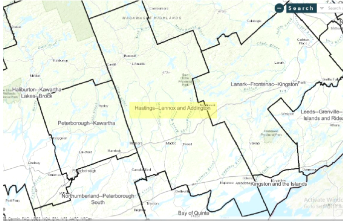
Proposed
- New Name - Hastings—Lennox and Addington—Tyendinaga
- Population: 111,331
- Consists of:
- that part of the City of Belleville lying northerly of Highway 401 (Macdonald-Cartier Freeway);
- the towns of Bancroft, Deseronto and Greater Napanee;
- the municipalities of Centre Hastings, Hastings Highlands, Marmora and Lake and Tweed;
- that part of the Municipality of Highlands East lying easterly of a line described as follows: commencing at the intersection of the northwesterly limit of said municipality with Highway 118; thence generally southeasterly along said highway to County Road 503; thence generally southwesterly along said road to Buckhorn Road; thence generally southerly along said road to the southerly limit of said municipality;
- the townships of Addington Highlands, Carlow/Mayo, Faraday, Havelock-Belmont-Methuen, Limerick, Loyalist, Madoc, North Kawartha, Stirling-Rawdon, Stone Mills, Tudor and Cashel, Tyendinaga and Wollaston; and
- Tyendinaga Mohawk Territory.
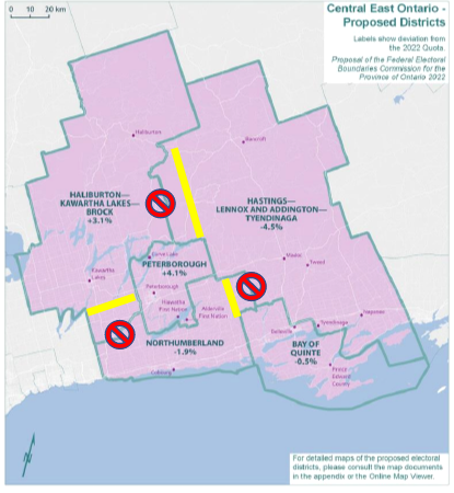
Proposed District Boundaries
- Current proposal adds a large geographic area to the north eastern area of the EDA which is sparsely populated.
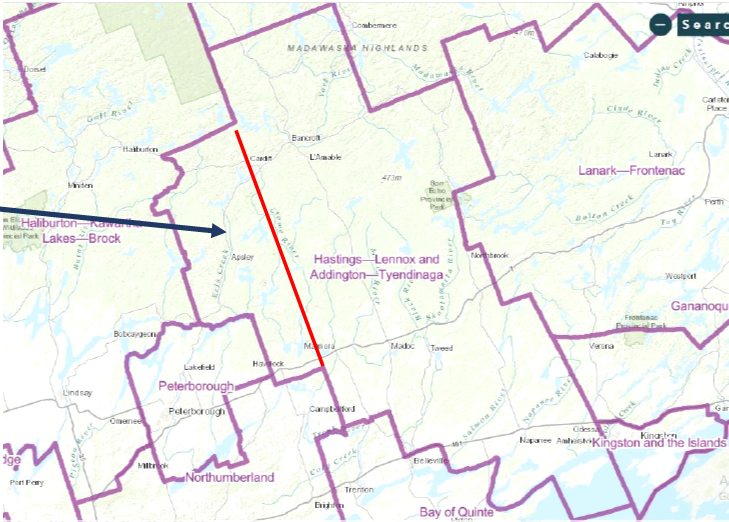
Discussion
Proposed boundary change adds another 10K population, about 20% more area.
- Adds rural communities which do not have natural linkages to H-L&A or Kingston.
- Apsley & Havelock in different County – they relate to Peterborough.
- Proposal takes population away from new Haliburton Kawartha Lakes Brock which is over quota and gives to new H LA T which is under quota.
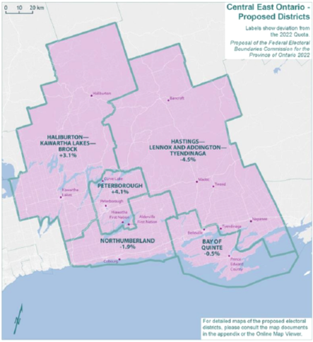
Recommended Alternative
Alternative-Push Northumberland western boundary north and change H-LA west
- Achieves desired population quota targets
- Keeps communities that naturally relate to each other, together.
Source: https://redecoupage-redistribution-2022.ca/com/on/prop/othaut/metb_e.aspx
| Electoral Districts | Population – 2011 | Deviation from Quota – 2012 | Population – 2021 | Deviation from Quota – 2022 |
|---|---|---|---|---|
| Bay of Quinte | 109,488 | 3.08% | 116,016 | -0.49% |
| Haliburton—Kawartha Lakes—Brock | 110,217 | 3.77% | 122,401 | 4.98% |
| Hastings—Lennox and Addington | 92,513 | -12.90% | 100,636 | -13.68% |
| Northumberland—Peterborough South | 107,840 | 1.53% | 118,756 | 1.86% |
| Peterborough—Kawartha | 115,264 | 8.52% | 125,478 | 7.62% |
| Average | 107,064 | 0.80% | 116,657 | 0.06% |
| Range (most populous to least populous) | 22,751 | 21.42 pp | 24,842 | 21.30 pp |