Commentaire 9 – commentaires et rétroaction
Les documents ci-dessous sont affichés dans la langue officielle d'origine tels qu'ils ont été reçus.
Retour aux commentaires et rétroaction du public
Ted Darby
2022 Federal Electoral Boundaries Commission
Eastern Ontario Realignment of Riding Boundaries
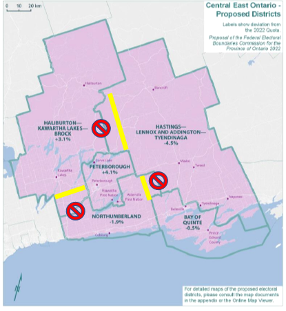
Hastings Lennox & Addington Alternative Riding Boundary Proposal
Submitted by: Ted Darby
Existing Federal Electoral District of Hastings Lennox & Addington
H-LA 2021
Population 100,636
Consisting of:
- the County of Hastings;
- the County of Lennox and Addington; and
- that part of the City of Belleville lying northerly of Highway No. 401.
Proposed
- New Name - Hastings—Lennox and Addington—Tyendinaga
- Population: 111,331
- Consists of:
- that part of the City of Belleville lying northerly of Highway 401 (Macdonald-Cartier Freeway);
- the towns of Bancroft, Deseronto and Greater Napanee;
- the municipalities of Centre Hastings, Hastings Highlands, Marmora and Lake and Tweed;
- that part of the Municipality of Highlands East lying easterly of a line described as follows: commencing at the intersection of the northwesterly limit of said municipality with Highway 118; thence generally southeasterly along said highway to County Road 503; thence generally southwesterly along said road to Buckhorn Road; thence generally southerly along said road to the southerly limit of said municipality;
- the townships of Addington Highlands, Carlow/Mayo, Faraday, Havelock-Belmont-Methuen, Limerick, Loyalist, Madoc, North Kawartha, Stirling-Rawdon, Stone Mills, Tudor and Cashel, Tyendinaga and Wollaston; and
- Tyendinaga Mohawk Territory.
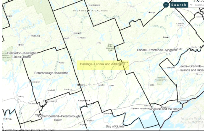
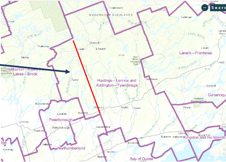
Proposed District Boundaries
- Current proposal adds a large geographic area to the north eastern area of the EDA which is sparsely populated.
Discussion
Proposed boundary change adds another 10K population, about 20% more area.
- Adds rural communities which do not have natural linkages to H-L&A or Kingston.
- Apsley & Havelock in different County – they relate to Peterborough.
- Proposal takes population away from new Haliburton Kawartha Lakes Brock which is over quota and gives to new H LA T which is under quota.
Recommended Alternative
Alternative-Push Northumberland western boundary north and change H-LA west
- Achieves desired population quota targets
- Keeps communities that naturally relate to each other, together.
Source: https://redecoupage-redistribution-2022.ca/com/on/prop/othaut/metb_e.aspx
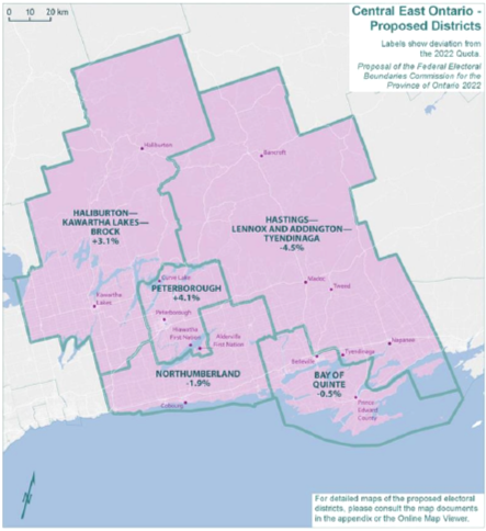
| Electoral Districts | Population – 2011 | Deviation from Quota – 2012 | Population – 2021 | Deviation from Quota – 2022 |
|---|---|---|---|---|
| Bay of Quinte | 109,488 | 3.08% | 116,016 | -0.49% |
| Haliburton—Kawartha Lakes—Brock | 110,217 | 3.77% | 122,401 | 4.98% |
| Hastings—Lennox and Addington | 92,513 | -12.90% | 100,636 | -13.68% |
| Northumberland—Peterborough South | 107,840 | 1.53% | 118,756 | 1.86% |
| Peterborough—Kawartha | 115,264 | 8.52% | 125,478 | 7.62% |
| Average | 107,064 | 0.80% | 116,657 | 0.06% |
| Range (most populous to least populous) | 22,751 | 21.42 pp | 24,842 | 21.30 pp |